| Mesoscale Discussion 983 | |
| < Previous MD | |

|
|
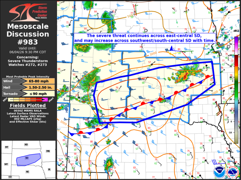
Mesoscale Discussion 0983 NWS Storm Prediction Center Norman OK 0731 PM CDT Thu Jun 04 2026 Areas affected...Parts of SD and extreme northwest NE Concerning...Severe Thunderstorm Watch 272...273... Valid 050031Z - 050230Z The severe weather threat for Severe Thunderstorm Watch 272, 273 continues. SUMMARY...The severe threat continues across parts of east-central South Dakota, with an increasing threat possible with time into south-central South Dakota. DISCUSSION...A cluster of intense storms has recently developed across east-central SD, to the west/north of Huron. This convection developed within a low-level confluence zone, within an environment characterized by MLCAPE of near/above 2000 J/kg and increasing effective shear in the 30-40 kt range. Large to locally very large hail and isolated severe gusts will continue to be a threat with these storms through mid evening, and a tornado cannot be ruled out given the presence of backed surface winds and modestly enhanced effective SRH. To the southwest of this cluster, isolated supercell development remains possible through dusk across south-central SD. Later this evening, outflow associated with convection across western SD may begin to intersect richer moisture and stronger buoyancy along and north of a surface boundary. This could lead to upscale growth and development of a small MCS (as depicted by recent HRRR runs), though this evolution is uncertain due to a lack of stronger low-level flow. Should such an evolution occur, a greater threat for severe gusts could develop across southwest into central SD later this evening. ..Dean.. 06/05/2026 ...Please see www.spc.noaa.gov for graphic product... ATTN...WFO...FSD...ABR...LBF...UNR... LAT...LON 44219675 43509816 42850071 42850153 42820252 43830286 44290272 44510152 44580102 44879954 45019781 45049685 44219675 MOST PROBABLE PEAK TORNADO INTENSITY...UP TO 90 MPH MOST PROBABLE PEAK WIND GUST...65-80 MPH MOST PROBABLE PEAK HAIL SIZE...1.50-2.50 IN |
|
|
Top/All Mesoscale Discussions/Forecast Products/Home |
|
Source link