| Mesoscale Discussion 981 | |
| < Previous MD | |
|
|
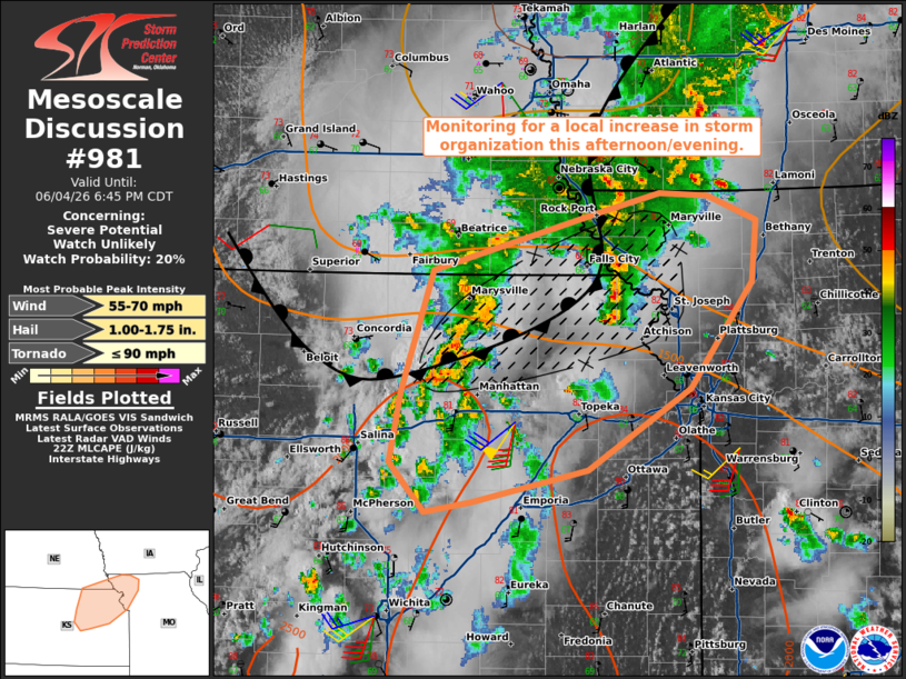
   Mesoscale Discussion 0981
   NWS Storm Prediction Center Norman OK
   0511 PM CDT Thu Jun 04 2026

   Areas affected...portions of northeastern Kansas into far southeast
   Nebraska and Northwestern Missouri

   Concerning...Severe potential...Watch unlikely

   Valid 042211Z - 042345Z

   Probability of Watch Issuance...20 percent

   SUMMARY...Increasing storm coverage and some organization has been
   noted with several cluster of thunderstorms over north-central KS in
   the last hour. This trend may continue with organization into a
   bowing cluster with a locally enhanced risk for damaging gusts and a
   couple of tornadoes.

   DISCUSSION...As of 22 UTC, regional visible and radar imagery showed
   an increase in convective coverage associated with an MCV and
   remnant outflow boundary near the KS/NE border. Several stronger
   clusters have emerged this afternoon, with the strongest over
   Marshall, Clay and Riley Counties in KS. This cluster has shown some
   organization, despite limited vertical shear, with a bowing
   structure and a recent reports of damage and a funnel cloud. If it
   can remain near or on the warmer side of the boundary, this segment
   may continue to organize as it interacts with the boundary where
   local convergence is stronger. This may support a locally enhanced
   corridor of damaging wind and brief tornado potential from northeast
   KS into northwestern MO this evening.

   Additional convective development is ongoing on the southern flank
   of this cluster into central KS, which may support further upscale
   growth or a supercell or two. While deep-layer shear remains quite
   limited, the very moist air mass combined with locally stronger 0-1
   SRH may support a brief/weak tornado hail or damaging gusts. An
   increase in the low-level jet this evening may allow for some
   organization or potential with any more persistent clusters this
   evening.

   ..Lyons/Guyer.. 06/04/2026

   ...Please see www.spc.noaa.gov for graphic product...

   ATTN...WFO...EAX...OAX...TOP...ICT...

   LAT...LON   38439661 38379702 38719734 39209724 40029696 40429548
               40559495 40539451 40379409 39959412 39229468 38659559
               38439661

   MOST PROBABLE PEAK TORNADO INTENSITY...UP TO 90 MPH
   MOST PROBABLE PEAK WIND GUST...55-70 MPH
   MOST PROBABLE PEAK HAIL SIZE...1.00-1.75 IN
|
|
|
Top/All Mesoscale Discussions/Forecast Products/Home |
|
Source link