| Mesoscale Discussion 980 | |
| < Previous MD | |

|
|
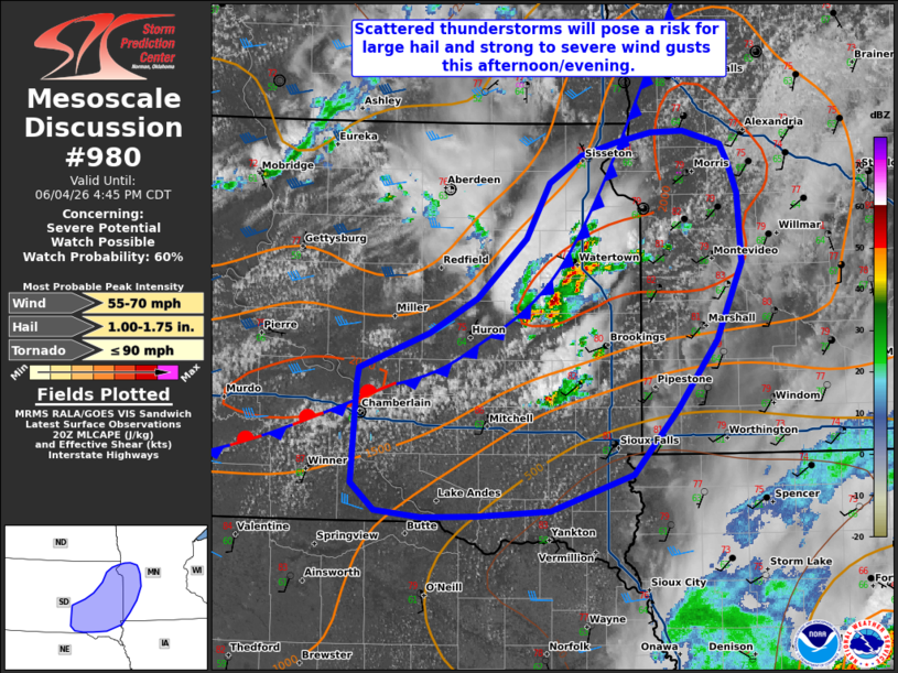
   Mesoscale Discussion 0980
   NWS Storm Prediction Center Norman OK
   0312 PM CDT Thu Jun 04 2026

   Areas affected...eastern South Dakota into southwestern Minnesota

   Concerning...Severe potential...Watch possible

   Valid 042012Z - 042145Z

   Probability of Watch Issuance...60 percent

   SUMMARY...Thunderstorm coverage is expected to increase across
   eastern South Dakota and southwestern Minnesota this
   afternoon/evening, with potential for large hail and strong to
   severe wind gusts.

   DISCUSSION...Thunderstorm coverage has increased over the past hour
   across portions of eastern South Dakota along/ahead of a slow moving
   surface cold front currently extending southwestward from near the
   ND/SD/MN border to south-central South Dakota. Ahead of this
   boundary, latest objective analysis indicates lingering inhibition
   is eroding, with warming temperatures contributing to MLCAPE of
   1500-2000 J/kg. While a marginal increase in mid-level flow is
   expected through the evening, effective shear will remain weaker
   than areas farther west (generally remaining less than 30-35 kts).
   This is likely to support an initially discrete storm mode (with
   marginal supercell structures possible) with a gradual transition to
   a more outflow-dominant, multicellular storm mode.

   While mid-level lapse rates are not as steep compared to areas
   farther west (evident via a comparison of the 18z UNR and ABR
   observed soundings), large hail will be possible with initially
   discrete convection and more robust updrafts. Steep low-level lapse
   rates will also promote a risk for strong to severe wind gusts. A
   brief tornado/landspout also cannot be ruled out should a stronger
   low-level updraft interact with marginally enhanced surface vertical
   vorticity/low-level shear in close proximity to the surface front.
   Trends are being monitored for possible Severe Thunderstorm Watch
   issuance.

   ..Chalmers/Mosier.. 06/04/2026

   ...Please see www.spc.noaa.gov for graphic product...

   ATTN...WFO...MPX...FGF...FSD...ABR...

   LAT...LON   43289941 44029936 44139934 44389861 44659813 45099763
               45509739 45699705 45799668 45879633 45879600 45789562
               45639553 45419544 44919541 44349567 43849607 43349652
               43089737 43049813 43029869 43079917 43289941

   MOST PROBABLE PEAK TORNADO INTENSITY...UP TO 90 MPH
   MOST PROBABLE PEAK WIND GUST...55-70 MPH
   MOST PROBABLE PEAK HAIL SIZE...1.00-1.75 IN
|
|
|
Top/All Mesoscale Discussions/Forecast Products/Home |
|
Source link