| Mesoscale Discussion 98 | |
| < Previous MD | |

|
|
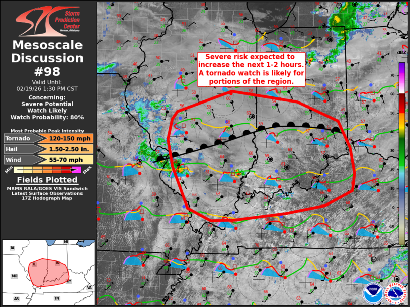
   Mesoscale Discussion 0098
   NWS Storm Prediction Center Norman OK
   1134 AM CST Thu Feb 19 2026

   Areas affected...portions of central/southern IL/IN into
   western/central KY

   Concerning...Severe potential...Watch likely

   Valid 191734Z - 191930Z

   Probability of Watch Issuance...80 percent

   SUMMARY...The severe risk will increase across central/southern
   Illinois and Indiana into western/central KY over the next 1-2
   hours. Storm coverage and intensity will gradually increase, along
   with a risk for large hail, tornadoes, and strong wind gusts. A
   tornado watch will likely be needed by 19z for portions of the
   region.

   DISCUSSION...Broken cloudiness has allowed temperatures to warm into
   the low/mid 60s across much of the region at midday. A warm front
   extending across central IL/IN will continue to gradually lift
   north. Across the moistening warm sector south of the front,
   dewpoints have increased to the low 60s along the Ohio River
   southward, and into the upper 50s south of the I-70 corridor. Cold
   temperatures in the 700-500 mb range atop the moistening boundary
   layer is supporting destabilization across the region. While MLCAPE
   is expected to remain modest, vertically veering wind profiles are
   present and will support supercell thunderstorms.

   Steep midlevel lapse rates and elongated/straight hodographs above
   2-3 km suggest large hail will be possible with these storms.
   Furthermore, enlarged, favorably curved low-level hodographs and 0-1
   km SRH increasing to 150-200 m2/s2 is forecast amid steepening
   low-level lapse rates. This should support a risk for tornadoes
   despite the modest boundary layer moisture. A couple of tornadoes
   could become strong, especially within a corridor from
   east-central/southeast IL into southern IN. A tornado watch is
   expected in the next 1-2 hours for portions of the region.

   ..Leitman/Mosier.. 02/19/2026

   ...Please see www.spc.noaa.gov for graphic product...

   ATTN...WFO...ILN...LMK...IND...PAH...ILX...LSX...

   LAT...LON   39798990 40288827 40038629 39568509 38938474 38348464
               37948471 37618553 37438668 37298818 37278885 37558953
               38509000 39149016 39609005 39798990

   MOST PROBABLE PEAK TORNADO INTENSITY...120-150 MPH
   MOST PROBABLE PEAK WIND GUST...55-70 MPH
   MOST PROBABLE PEAK HAIL SIZE...1.50-2.50 IN
|
|
|
Top/All Mesoscale Discussions/Forecast Products/Home |
|
Source link