| Mesoscale Discussion 977 | |
| < Previous MD Next MD > | |

|
|
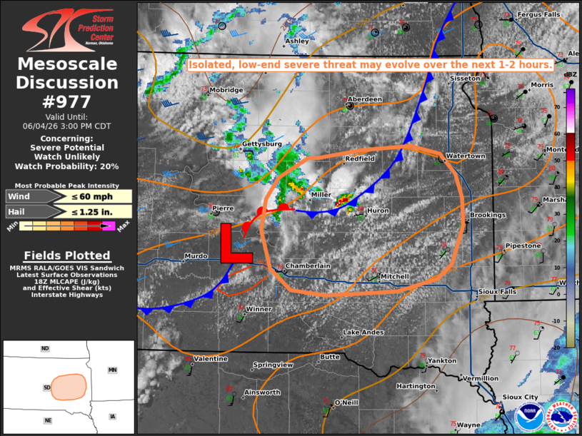
   Mesoscale Discussion 0977
   NWS Storm Prediction Center Norman OK
   0126 PM CDT Thu Jun 04 2026

   Areas affected...portions of central/eastern South Dakota

   Concerning...Severe potential...Watch unlikely

   Valid 041826Z - 042000Z

   Probability of Watch Issuance...20 percent

   SUMMARY...A few instances of small to marginally severe hail and
   strong wind gusts may occur with with convection along a surface
   frontal boundary through early-to-mid afternoon. Storm coverage and
   severe potential are the expected to increase later this
   afternoon/evening.

   DISCUSSION...Latest regional radar imagery depicts isolated
   thunderstorms ongoing along a surface frontal boundary ahead of a
   weak surface low analyzed southeast of Pierre, South Dakota. IR
   satellite imagery has depicted brief periods of cooler cloud tops
   indicative of marginally stronger/deeper updraft development. Steep
   mid-level lapse rates (as sampled by the 18z UNR/ABR observed
   soundings) and effective shear of 25-35 kts may support isolated
   small to marginally severe hail and strong wind gusts with this
   activity over the next 1-2 hours. Latest objective analysis also
   indicates MLCIN continues to erode, with deepening cumulus noted on
   visible satellite imagery south of the frontal boundary amid warming
   surface temperatures. This should promote a gradual increase in
   storm coverage and severe threat later this afternoon.

   ..Chalmers/Mosier.. 06/04/2026

   ...Please see www.spc.noaa.gov for graphic product...

   ATTN...WFO...FSD...ABR...

   LAT...LON   44519958 44729942 44929901 44929888 45009825 45059758
               44969717 44769696 44539688 44269687 43889703 43739722
               43619777 43589825 43579876 43629924 43829951 44219964
               44519958

   MOST PROBABLE PEAK WIND GUST...UP TO 60 MPH
   MOST PROBABLE PEAK HAIL SIZE...UP TO 1.25 IN
|
|
|
Top/All Mesoscale Discussions/Forecast Products/Home |
|
Source link