|
|
| Mesoscale Discussion 975 | |
| < Previous MD | |

|
|
   Mesoscale Discussion 0975
   NWS Storm Prediction Center Norman OK
   1213 PM CDT Sun May 26 2024

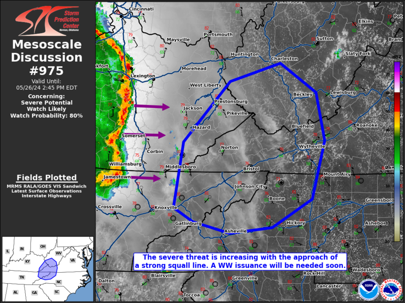
   Areas affected...far eastern Kentucky...far northeast
   Tennessee...far southern West Virginia...extreme western
   Virginia...extreme western North Carolina

   Concerning...Severe potential...Watch likely

   Valid 261713Z - 261845Z

   Probability of Watch Issuance...80 percent

   SUMMARY...The severe threat is increasing across portions of the
   central Appalachians region as a line of storms approaches from the
   west. Damaging gusts are the main threat, though a QLCS tornado
   cannot be ruled out. A WW issuance will be needed soon to address
   the increasing severe threat.

   DISCUSSION...A mature QLCS continues to rapidly track eastward
   across the OH and TN Valley areas with an extensive history of
   damaging gusts, and numerous measured 45+ mph gusts (as sampled by
   the Kentucky Mesonet). Surface temperatures have warmed into the
   upper 70s to near 80F amid mid 60s F dewpoints, with MLCAPE
   exceeding 1000 J/kg. Effective bulk shear (with vectors oriented
   normal to the leading line of the approaching storms) is rapidly
   increasing to 50 kts as a 500 mb speed max approaches the central
   Appalachians. As such, damaging gusts are expected to continue east
   of Tornado Watch 315 for at least a few more hours, and a WW
   issuance will be needed downstream.

   ..Squitieri/Bunting.. 05/26/2024

   ...Please see www.spc.noaa.gov for graphic product...

   ATTN...WFO...RNK...RLX...GSP...MRX...JKL...

   LAT...LON   36168080 35708159 35618242 35798314 36018352 37078335
               38048243 38328141 37858071 37098055 36168080
|
|
|
Top/All Mesoscale Discussions/Forecast Products/Home |
|


