|
|
| Mesoscale Discussion 974 | |
| < Previous MD | |

|
|
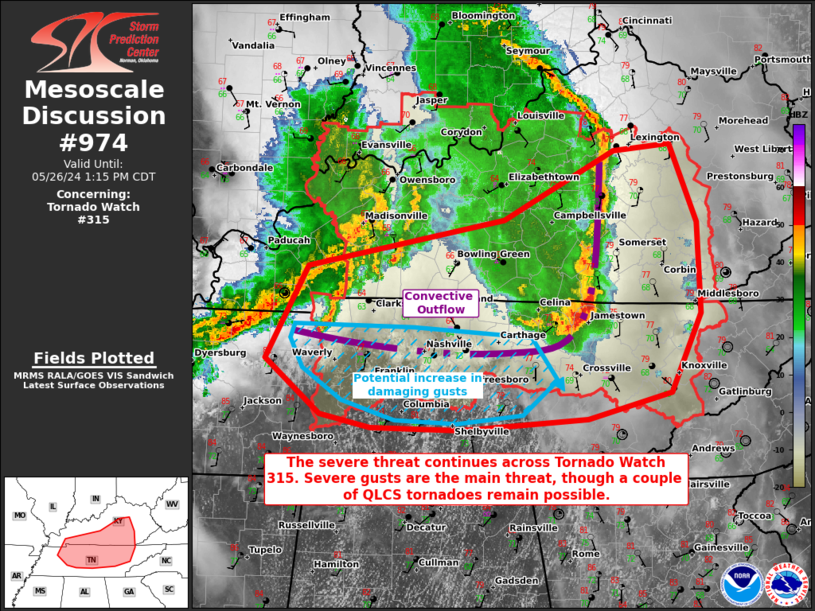
Mesoscale Discussion 0974 NWS Storm Prediction Center Norman OK 1152 AM CDT Sun May 26 2024 Areas affected...northern and middle Tennessee into central Kentucky Concerning...Tornado Watch 315... Valid 261652Z - 261815Z The severe weather threat for Tornado Watch 315 continues. SUMMARY...The severe threat continues across Tornado Watch 315, both with a bow echo across eastern KY into northern TN, and with another round of storms approaching from the west. Damaging gusts are possible with both lines of storms, and QLCS tornadoes cannot be ruled out with storms interacting with a pristine airmass. DISCUSSION...Multiple rounds of thunderstorms are currently progressing across the TN Valley area. The first is a longer-lived QLCS with a history of damaging gusts (some severe) that is currently moving across eastern KY and far northern TN. The second is an intensifying line of storms trailing the previous QLCS in an overturned airmass. The first QLCS should continue to progress eastward with a damaging gust threat for at least a couple more hours. With the line oriented roughly perpendicular to the deep-layer shear vectors, a QLCS tornado remains possible. The second line of storms to the west is traversing a stable airmass and is currently ingesting elevated but buoyant air parcels given appreciable 850 mb WAA. However, southern portions of this line may cross the cold pool boundary of the previous QLCS into surface-based, buoyant air, characterized by surface temperatures and dewpoints into the low 80s F/70sF (respectively). In this environment, MLCAPE increases to 2000 J/kg amid 60+ kts of effective bulk shear. As such, damaging gusts and perhaps a brief QLCS tornado could accompany portion of this line that can ingest surface-based parcels. ..Squitieri.. 05/26/2024 ...Please see www.spc.noaa.gov for graphic product... ATTN...WFO...MRX...JKL...LMK...OHX...PAH...MEG... LAT...LON 36928809 37358588 37988463 38058399 37338369 36508366 35778399 35538494 35438636 35468737 35588795 36078857 36928809 |
|
|
Top/All Mesoscale Discussions/Forecast Products/Home |
|


