|
|
| Mesoscale Discussion 962 | |
| < Previous MD | |

|
|
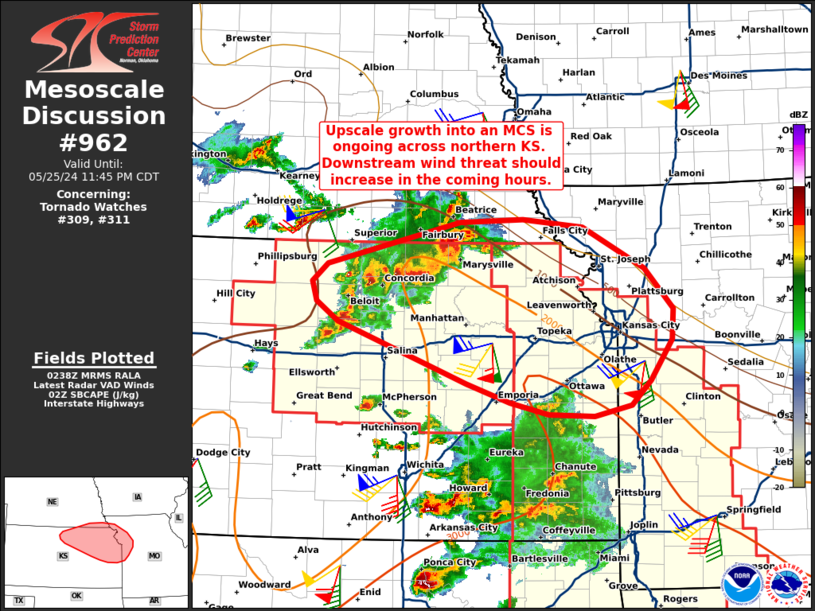
Mesoscale Discussion 0962 NWS Storm Prediction Center Norman OK 0941 PM CDT Sat May 25 2024 Areas affected...Northeast Kansas Concerning...Tornado Watch 309...311... Valid 260241Z - 260445Z The severe weather threat for Tornado Watch 309, 311 continues. SUMMARY...Upscale growth into an MCS appears to be ongoing across northeast Kansas. Consequently, the wind threat should gradually increase in the coming hours downstream. DISCUSSION...Gradual upscale growth appears to be occurring across northeast KS with KGID and KTWX reflectivity and velocity data suggesting that cold pool consolidation is underway. A more notable wind surge is noted in on the northern periphery of the line across Washington county, which may be the development of an MCV-like feature that will act to better organize the developing MCS (though embedded supercells will remain possible on the southwestern flank of the line). VWP observations from KTWX show southerly winds in the lowest kilometer increasing to 50 knots over the past hour, which will will enhance convergence on the southern flank of the cold pool. Additionally, a moisture/buoyancy axis is noted in recent objective analyses across eastern KS into western/central MO. Based on these observations, the expectation is for the MCS to begin propagating to the east/southeast over the coming hours with an attendant increase in severe wind potential. Given the strong low-level SRH (0-1 km SRH near 500 m2/s2 per KTWX VWP), embedded circulations appear possible. ..Moore.. 05/26/2024 ...Please see www.spc.noaa.gov for graphic product... ATTN...WFO...EAX...OAX...TOP...ICT...GID... LAT...LON 39599856 39789837 40219664 40249582 40159504 39739425 39329388 39029389 38609417 38369442 38259490 38269549 38389600 38579655 39199823 39399851 39599856 |
|
|
Top/All Mesoscale Discussions/Forecast Products/Home |
|


