| Mesoscale Discussion 960 | |
| < Previous MD | |

|
|
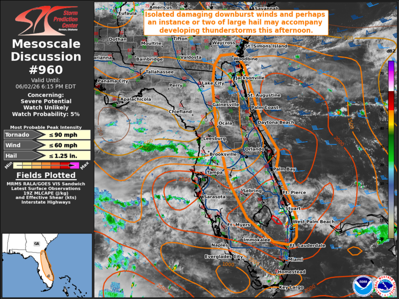
   Mesoscale Discussion 0960
   NWS Storm Prediction Center Norman OK
   0242 PM CDT Tue Jun 02 2026

   Areas affected...portions of the Florida Peninsula

   Concerning...Severe potential...Watch unlikely

   Valid 021942Z - 022215Z

   Probability of Watch Issuance...5 percent

   SUMMARY...Developing thunderstorms may bring a threat for isolated
   damaging downburst winds and perhaps an instance or two of large
   hail along the eastern Florida Peninsula this afternoon/evening.

   DISCUSSION...Latest GOES visible satellite imagery and lightning
   data indicate an uptick in thunderstorm development across the
   eastern Florida Peninsula over the last 30-60 minutes, with
   west-northwesterly, deep-layer flow continuing to favor low-level
   convergence along the Atlantic Coast sea breeze. Isolated
   thunderstorms near the Jacksonville area have largely struggled to
   intensify thus far, likely owing to lingering warm mid/upper level
   temperatures around 400 mb sampled by a recent JAX ACARS profile.
   Increasing ascent ahead of an approaching upper-level trough across
   North Florida (evident in the 12/18z JAX observed soundings) should
   continue to support cooling mid-level temperatures. While convective
   coverage remains somewhat uncertain (especially across portions of
   the northern Peninsula where objective analysis depicts some
   lingering inhibition), this should allow for some increase in storm
   coverage and intensity through the afternoon.

   Moderate to strong buoyancy (1500-3000+ J/kg MLCAPE per latest
   objective analysis) and modest west/northwesterly flow aloft (as
   sampled by regional VAD profiles) will support some updraft
   organization with any developing storms, with multicells and
   marginal supercell structures possible. PWAT contents of 1.7+ inches
   will promote water-loaded downdrafts capable of isolated damaging
   wind gusts. Poor mid-level lapse rates will largely temper the
   overall hail risk, but an instance or two of large hail may
   accompany the most robust updrafts. An isolated landspout/waterspout
   may also be possible where a stronger low-level updraft can interact
   with enhanced surface vertical vorticity along the sea breeze and/or
   an outflow boundary. The greatest severe risk is likely to manifest
   seaward of the Atlantic Coast sea breeze, where easterly winds and
   greater moisture in the low-levels will support greater buoyancy and
   enhanced effective shear. Watch issuance is not expected due to the
   expectation for severe coverage/magnitude to remain limited,
   however.

   ..Chalmers/Mosier.. 06/02/2026

   ...Please see www.spc.noaa.gov for graphic product...

   ATTN...WFO...MFL...MLB...TBW...JAX...

   LAT...LON   26898128 27838182 29208218 30258230 30728225 30988207
               31028169 30908153 30738138 30378124 29318089 28588041
               28458039 28198046 27328005 26877991 26417992 26278003
               26238016 26298054 26898128

   MOST PROBABLE PEAK TORNADO INTENSITY...UP TO 90 MPH
   MOST PROBABLE PEAK WIND GUST...UP TO 60 MPH
   MOST PROBABLE PEAK HAIL SIZE...UP TO 1.25 IN
|
|
|
Top/All Mesoscale Discussions/Forecast Products/Home |
|
Source link