| Mesoscale Discussion 958 | |
| < Previous MD | |

|
|
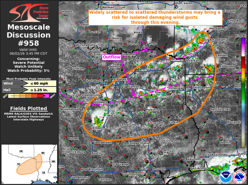
   Mesoscale Discussion 0958
   NWS Storm Prediction Center Norman OK
   0108 PM CDT Tue Jun 02 2026

   Areas affected...portions of central/eastern Texas into northwestern
   Louisiana and southwestern Arkansas

   Concerning...Severe potential...Watch unlikely

   Valid 021808Z - 022045Z

   Probability of Watch Issuance...5 percent

   SUMMARY...Widely scattered to scattered thunderstorms are expected
   this afternoon across portions of central/eastern Texas into
   northwestern Louisiana and southwestern Arkansas. Locally damaging
   wind gusts may accompany the strongest storms.

   DISCUSSION...Latest surface analysis depicts a remnant outflow
   boundary extending roughly west-to-east from north-central Texas
   into northeast Texas and far northwestern Louisiana, with a separate
   convective outflow boundary analyzed to the north across
   southeastern Oklahoma/southwestern Arkansas. South of this secondary
   outflow boundary, temperatures in the low 90s F with low-to-mid 70s
   dewpoints are supporting strong buoyancy (MLCAPE 3000-3500+ J/kg per
   latest objective analysis). Expectation is for thunderstorm coverage
   to continue to increase through the afternoon along these boundaries
   before moving generally south-southwestward.

   Weak deep-layer flow under an upper-level anticyclone will limit
   effective shear through the afternoon, with values forecast to
   remain below 15-20 kts. While this will largely inhibit
   updraft/storm organization, high PWAT contents (1.7+ inches) within
   the strongly unstable environment will support water-loaded
   downdrafts capable of isolated damaging wind gusts. Small to
   marginally severe hail may also accompany the strongest convective
   cores despite limited effective shear and only modestly steep
   mid-level lapse rates (as sampled by the 12z FWD observed sounding).
   Watch issuance is not expected given the limited potential for storm
   organization and the resultant low severe magnitude.

   ..Chalmers/Mosier.. 06/02/2026

   ...Please see www.spc.noaa.gov for graphic product...

   ATTN...WFO...LZK...SHV...HGX...FWD...

   LAT...LON   34419350 34469329 34399315 34289303 33619282 33149280
               32529293 31729354 31039503 30859616 30769715 30919774
               31189802 31489809 31779800 32009787 32429740 32829683
               33289594 33619517 33909421 34129376 34419350

   MOST PROBABLE PEAK WIND GUST...UP TO 60 MPH
   MOST PROBABLE PEAK HAIL SIZE...UP TO 1.25 IN
|
|
|
Top/All Mesoscale Discussions/Forecast Products/Home |
|
Source link