| Mesoscale Discussion 956 | |
| < Previous MD | |

|
|
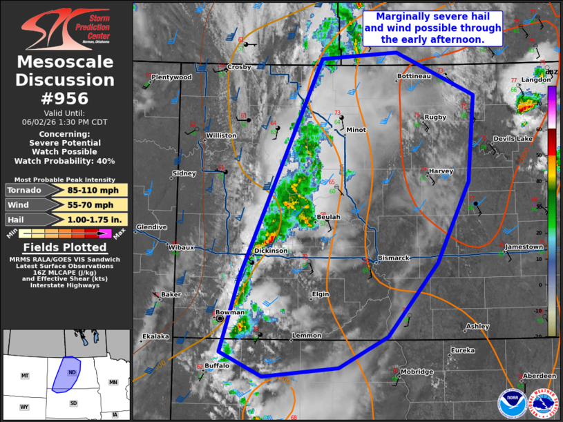
   Mesoscale Discussion 0956
   NWS Storm Prediction Center Norman OK
   1159 AM CDT Tue Jun 02 2026

   Areas affected...central North Dakota into north-central South
   Dakota

   Concerning...Severe potential...Watch possible

   Valid 021659Z - 021830Z

   Probability of Watch Issuance...40 percent

   SUMMARY...A few instances of marginally severe hail and strong to
   severe wind will be possible with storms along the cold front
   through early afternoon. Additional stronger storms are expected
   later in the afternoon and evening.

   DISCUSSION...Thunderstorm activity near the front in central North
   Dakota/far northern South Dakota has shown occasional strengthening
   MESH cores with marginally severe hail (with up to penny size hail
   reported). For now, MLCIN remains in place across much of the
   Dakotas but it is steadily beginning to erode to the north with
   daytime heating and warming surface temperatures. Deep layer shear
   around 30-40 kts may support a few instances of small to severe hail
   and strong to severe wind may evolve before a more pronounced severe
   threat develops into the afternoon.

   ..Thornton/Mosier.. 06/02/2026

   ...Please see www.spc.noaa.gov for graphic product...

   ATTN...WFO...FGF...ABR...BIS...UNR...

   LAT...LON   49070166 46650298 45790330 45520261 45620139 45970059
               46809977 47709925 48659916 49140043 49070166

   MOST PROBABLE PEAK TORNADO INTENSITY...85-110 MPH
   MOST PROBABLE PEAK WIND GUST...55-70 MPH
   MOST PROBABLE PEAK HAIL SIZE...1.00-1.75 IN
|
|
|
Top/All Mesoscale Discussions/Forecast Products/Home |
|
Source link