| Mesoscale Discussion 950 | |
| < Previous MD | |

|
|
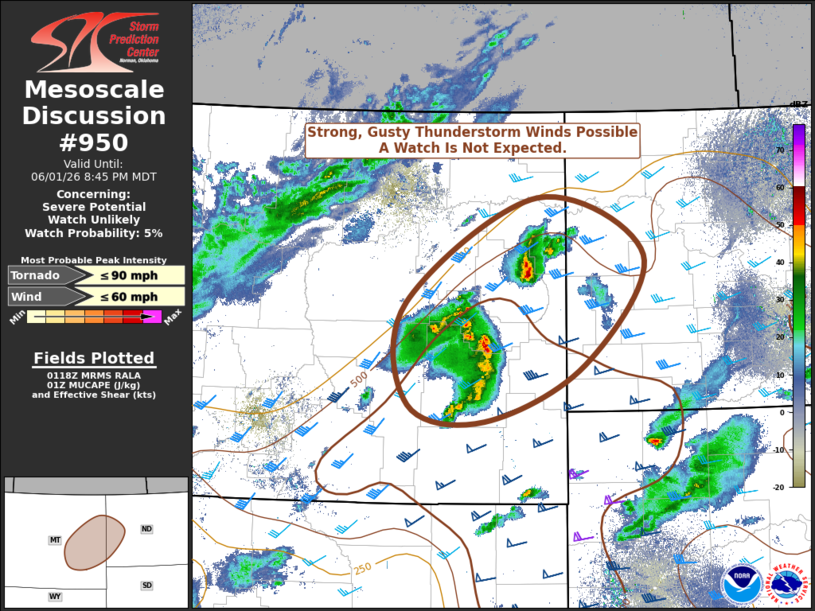
   Mesoscale Discussion 0950
   NWS Storm Prediction Center Norman OK
   0819 PM CDT Mon Jun 01 2026

   Areas affected...eastern Montana and far western North Dakota

   Concerning...Severe potential...Watch unlikely

   Valid 020119Z - 020245Z

   Probability of Watch Issuance...5 percent

   SUMMARY...Developing thunderstorms across the region will pose a
   threat for strong, gusty thunderstorm winds capable of producing
   isolated damage. A watch is not expected given the isolated nature
   of the threat.

   DISCUSSION...Thunderstorms are developing across eastern Montana
   this evening in association with modest large-scale ascent
   associated with a strong mid-upper-level cyclone across the
   Montana/Canada border. Additionally, an 80-knot upper-level jet
   streak is nosing across the area.

   Modest instability (MUCAPE around 1000 J/kg or less) and strong
   deep-layer shear on the order of 50 knots will support strong, gusty
   thunderstorm winds given the overall strength of the flow. The
   threat should diminish later this evening as the storms move into an
   increasingly stable environment.

   A watch is not anticipated given the isolated nature of any severe
   potential.

   ..Marsh.. 06/02/2026

   ...Please see www.spc.noaa.gov for graphic product...

   ATTN...WFO...BIS...BYZ...GGW...

   LAT...LON   46000639 47050643 48120447 47540287 46410376 45840526
               46000639

   MOST PROBABLE PEAK TORNADO INTENSITY...UP TO 90 MPH
   MOST PROBABLE PEAK WIND GUST...UP TO 60 MPH
|
|
|
Top/All Mesoscale Discussions/Forecast Products/Home |
|
Source link