| Mesoscale Discussion 95 | |
| < Previous MD | |

|
|
Mesoscale Discussion 0095
NWS Storm Prediction Center Norman OK
0416 AM CST Wed Feb 18 2026
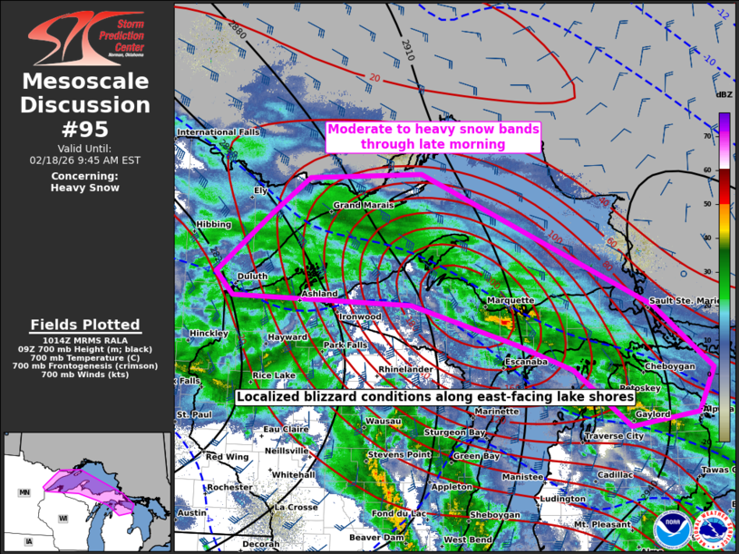
Areas affected...MN North Shore to far northern Lower MI
Concerning...Heavy snow
Valid 181016Z - 181445Z
SUMMARY...Moderate to heavy snow bands will increase in coverage
through late morning along portions of the Minnesota North Shore to
far northern Lower Michigan. Rates of 1 to 2 inches per hour should
be common, with localized blizzard conditions along east-facing lake
shores.
DISCUSSION...Leading swath of moderate to heavy snow has been most
persistent across the MN North Shore to the Keweenaw Peninsula of
western Upper MI. An upstream lobe of strongly forced ascent from
east-central MN to southeast WI will shift northeast through late
morning. While the activity attendant to this ascent is largely
rain, including a flurry of recent thunderstorms in southern WI, it
will transition to winter precipitation types as it spreads across
the Upper Great Lakes. Snowfall rates will likely be enhanced with
transient bursts of 2 to 3 in/hr possible along the interface of
sleet/freezing rain to all snow transition. Where this transition
point occurs is more uncertain with southeast extent in MI, where
subtle differences in the low-level thermal profile should have
profound impact on the degree of mixed-phase precip versus nearly
all snow.
Localized blizzard conditions along east-facing lake shores should
persist into late morning, before eventually waning as the surface
pressure gradient relaxes towards midday.
..Grams.. 02/18/2026
...Please see www.spc.noaa.gov for graphic product...
ATTN...WFO...APX...MQT...DLH...
LAT...LON 46929247 47719142 48179074 48248860 46528424 45688315
45118344 44958470 45698575 46038682 46548878 46629214
46929247
|
|
|
Top/All Mesoscale Discussions/Forecast Products/Home |
|
Source link