| Mesoscale Discussion 947 | |
| < Previous MD | |

|
|
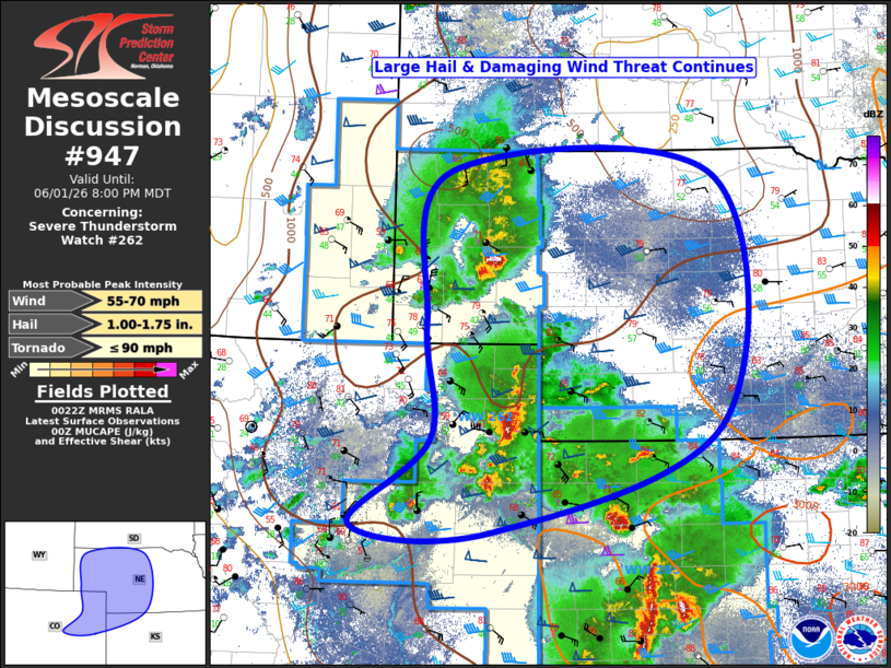
Mesoscale Discussion 0947 NWS Storm Prediction Center Norman OK 0723 PM CDT Mon Jun 01 2026 Areas affected...northeast Colorado...western Nebraska...and far northwest Kansas Concerning...Severe Thunderstorm Watch 262... Valid 020023Z - 020200Z The severe weather threat for Severe Thunderstorm Watch 262 continues. SUMMARY...Severe thunderstorms will continue moving east across the area this evening. A new watch will likely be needed east of Severe Thunderstorm Watch #262. DISCUSSION...Multiple clusters of severe thunderstorms continue across Severe Thunderstorm Watch #262 this evening. One such cluster is moving east across the Nebraska panhandle. This cluster has a history of producing hail around 1" and a brief tornado. To the south, another cluster of storms is moving east across northeast Colorado into northwest Kansas. This cluster also has a history of producing severe reports, with a 1" hail report noted near Yuma, CO. These storms are ongoing within a favorable environment for severe storms, with MUCAPE around 500-1000 J/kg (increasing to greater than 1500 J/kg ahead of the storms) and effective-layer shear on the order of 40-50 knots. These storms should continue moving east and may eventually grow upscale and merge into a linear system as it moves east out of the Severe Thunderstorm Watch. As such, a new watch will likely be needed east of Watch #262. ..Marsh.. 06/02/2026 ...Please see www.spc.noaa.gov for graphic product... ATTN...WFO...GID...LBF...GLD...PUB...BOU...CYS... LAT...LON 39120459 40000350 41200357 42770326 42749964 40159956 39040268 39120459 MOST PROBABLE PEAK TORNADO INTENSITY...UP TO 90 MPH MOST PROBABLE PEAK WIND GUST...55-70 MPH MOST PROBABLE PEAK HAIL SIZE...1.00-1.75 IN |
|
|
Top/All Mesoscale Discussions/Forecast Products/Home |
|
Source link