|
|
| Mesoscale Discussion 942 | |
| < Previous MD | |

|
|
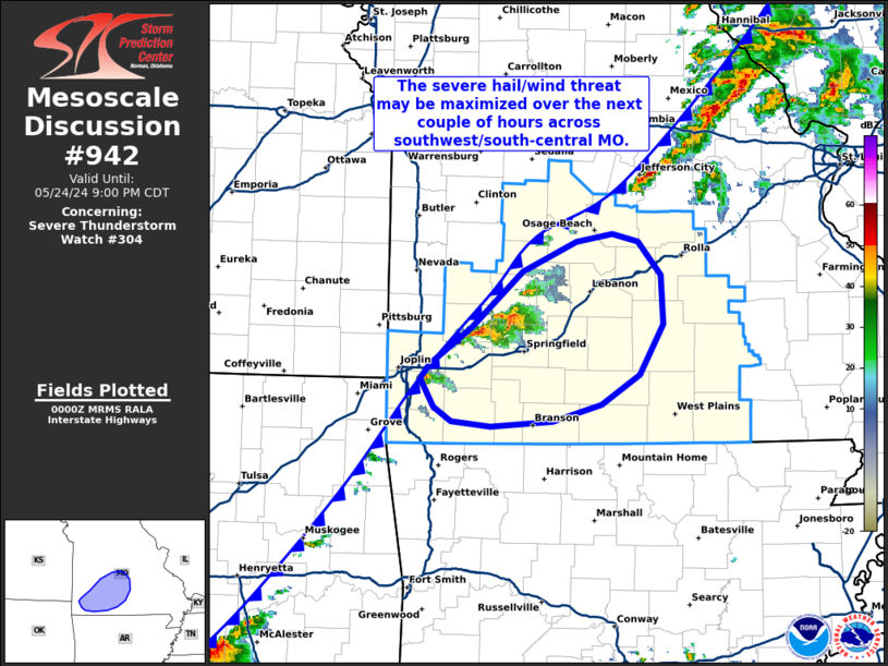
Mesoscale Discussion 0942 NWS Storm Prediction Center Norman OK 0703 PM CDT Fri May 24 2024 Areas affected...Southwest Missouri Concerning...Severe Thunderstorm Watch 304... Valid 250003Z - 250200Z The severe weather threat for Severe Thunderstorm Watch 304 continues. SUMMARY...The severe threat across southwest Missouri may be maximized over the next couple of hours. The primary threats remain large hail and damaging wind gusts. DISCUSSION...Despite numerous early attempts at convective initiation, only a few robust convective cells have been sustained over the past hour or so across southwest MO. This may be attributed to a gradually slowing frontal motion (and thus weakening forcing for ascent) across the region as stronger synoptic lift glances the region to the north. Regardless, MRMS and GOES IR imagery show a couple of robust supercells have become established and may persist for the next 1-2 hours as they migrate across an MLCAPE buoyancy axis. The KSGF VWP has recently sampled realtively weak (20 knots or less) winds in the 0-2 km layer with stronger (~40 knot) winds between 5-6 km. Consequently, regional hodographs appear to be sufficiently elongated to continue to support supercells, and should remain so through mid/late evening. Large hail (possibly up to 2 inches in diameter) and damaging winds remain the most probable hazards given the poor low-level hodograph structure. It remains unclear how long cells will persist into south-central MO later this evening, and additional storms appear possible based on recent visible imagery trends along the front (though perhaps not probable given the approaching onset of nocturnal cooling). Regardless, the severe threat should be focused to two to three cells heading into the late evening. ..Moore.. 05/25/2024 ...Please see www.spc.noaa.gov for graphic product... ATTN...WFO...SGF... LAT...LON 36669301 36629362 36669400 36779417 37009430 37109421 37409379 37829330 38059279 38119244 38059218 37809196 37419194 37039217 36809254 36669301 |
|
|
Top/All Mesoscale Discussions/Forecast Products/Home |
|


