| Mesoscale Discussion 941 | |
| < Previous MD Next MD > | |

|
|
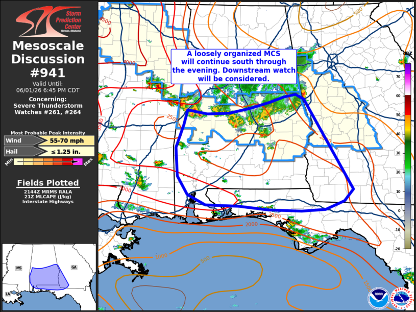
Mesoscale Discussion 0941 NWS Storm Prediction Center Norman OK 0446 PM CDT Mon Jun 01 2026 Areas affected...Southern Alabama into the Florida Panhandle and adjacent portions of southwest Georgia Concerning...Severe Thunderstorm Watch 261...264... Valid 012146Z - 012345Z The severe weather threat for Severe Thunderstorm Watch 261, 264 continues. SUMMARY...A loosely organized MCS will likely continue propagating southward across southern Alabama and into the Florida Panhandle through the evening hours. Downstream watch issuance will be considered. DISCUSSION...Latest velocity imagery out of central AL continues to show pockets of winds approaching 50 knots along the leading edge of the surging cold pool/outflow boundary of a southward-propagating MCS. Similarly, the KBMX VWP recently sampled 40-50 knot flow within the 1-2 km layer with the passage of the MCS. While severe winds likely reside just above the surface, recent surface observations continue to mostly show gusts between 30-45 mph, which have been sufficient for wind damage based on recent storm reports. The surging nature of the outflow suggests some weakening may be observed in the next few hours, however, a pocket of MLCAPE of around 2500 J/kg is noted downstream of the MCS where pulse convection is currently developing. This hints that new convective development along the outflow is possible and could maintain some degree of MCS intensity into the evening hours. Downstream watch issuance is being considered as the MCS approaches the southern edge of WW 261 and 264. ..Moore.. 06/01/2026 ...Please see www.spc.noaa.gov for graphic product... ATTN...WFO...FFC...TAE...BMX...MOB... LAT...LON 30648763 30858810 31268835 31878840 32378821 32708813 32618761 32638707 32748651 32878601 32998564 33048535 32958513 30968390 30718413 30548462 30518522 30548604 30618681 30648763 MOST PROBABLE PEAK WIND GUST...55-70 MPH MOST PROBABLE PEAK HAIL SIZE...UP TO 1.25 IN |
|
|
Top/All Mesoscale Discussions/Forecast Products/Home |
|
Source link