|
|
| Mesoscale Discussion 939 | |
| < Previous MD | |

|
|
   Mesoscale Discussion 0939
   NWS Storm Prediction Center Norman OK
   0446 PM CDT Fri May 24 2024

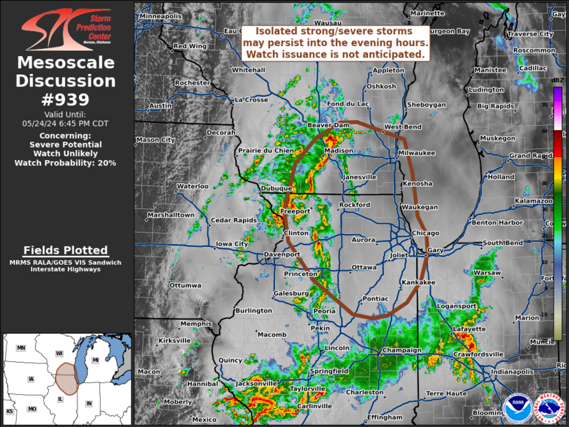
   Areas affected...Northern Illinois into southeast Wisconsin

   Concerning...Severe potential...Watch unlikely

   Valid 242146Z - 242345Z

   Probability of Watch Issuance...20 percent

   SUMMARY...Scattered thunderstorms will continue to spread northeast
   into northern Illinois and southeast Wisconsin through the evening
   hours. A few strong to severe storms are possible, but the overall
   threat should remain sufficiently limited to preclude watch
   issuance.

   DISCUSSION...Several thunderstorm clusters continue to move
   northeast from northwest IL/eastern IA towards northern IL/southern
   WI. GOES IR imagery has shown steadily cooling cloud top
   temperatures with this activity, suggesting some degree of
   intensification; however, MRMS vertically integrated ice (and other
   radar-based measures of convective intensity) show that most of the
   stronger updrafts/convective cores have been relatively short-lived.
   Some degree of air mass recovery has taken place across northern
   IL/southern WI with temperatures rebounding into the 70s, but cloud
   debris has limited overall destabilization, and RAP forecast
   soundings hint that low-level lapse rates are fairly marginal with
   some degree of lingering MLCIN. East/southeasterly low-level winds
   under 40 knot mid-level flow should continue to support transient
   storm organization with the deeper/stronger cells, but the marginal
   thermodynamic environment should modulate the overall severe threat.
   Sporadic damaging winds/hail, and perhaps a brief tornado, appear
   possible given the kinematic environment, but should be sufficiently
   isolated to preclude watch issuance.

   ..Moore/Thompson.. 05/24/2024

   ...Please see www.spc.noaa.gov for graphic product...

   ATTN...WFO...LOT...ILX...MKX...DVN...

   LAT...LON   40718878 41218955 41789006 42259016 42948995 43328953
               43568904 43578871 43318774 42808759 42178749 41898732
               41628731 41218744 40898773 40698811 40668840 40718878
|
|
|
Top/All Mesoscale Discussions/Forecast Products/Home |
|


