| Mesoscale Discussion 937 | |
| < Previous MD | |

|
|
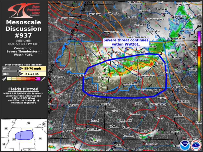
Mesoscale Discussion 0937 NWS Storm Prediction Center Norman OK 0218 PM CDT Mon Jun 01 2026 Areas affected...portions of central Alabama and west-central Mississippi Concerning...Severe Thunderstorm Watch 261... Valid 011918Z - 012115Z The severe weather threat for Severe Thunderstorm Watch 261 continues. SUMMARY...Severe threat continues within WW261. Local watch extension may be needed as storms continue southward. DISCUSSION...A line of storms continues south and east across portions of northern/central Alabama into western Mississippi this afternoon, producing gusts generally 45-50 mph. This line of storms is moving along a gradient of higher instability that extends across central Alabama into Mississippi, with additional development on the western flank of the southward moving outflow in western Mississippi. Ahead of the line of storms, the downstream air mass remains favorably hot and unstable. Guidance suggests that the damaging wind threat may extend further downstream into portions of central Mississippi and Alabama. Local extension may be needed to WW261 to cover this potential. ..Thornton.. 06/01/2026 ...Please see www.spc.noaa.gov for graphic product... ATTN...WFO...BMX...HUN...MEG...JAN... LAT...LON 33918930 34238830 34498649 34478583 34108552 33648547 33038550 32768608 32708696 32708795 32748865 32818922 32988951 33558952 33918930 MOST PROBABLE PEAK WIND GUST...55-70 MPH MOST PROBABLE PEAK HAIL SIZE...UP TO 1.25 IN |
|
|
Top/All Mesoscale Discussions/Forecast Products/Home |
|
Source link