| Mesoscale Discussion 935 | |
| < Previous MD | |

|
|
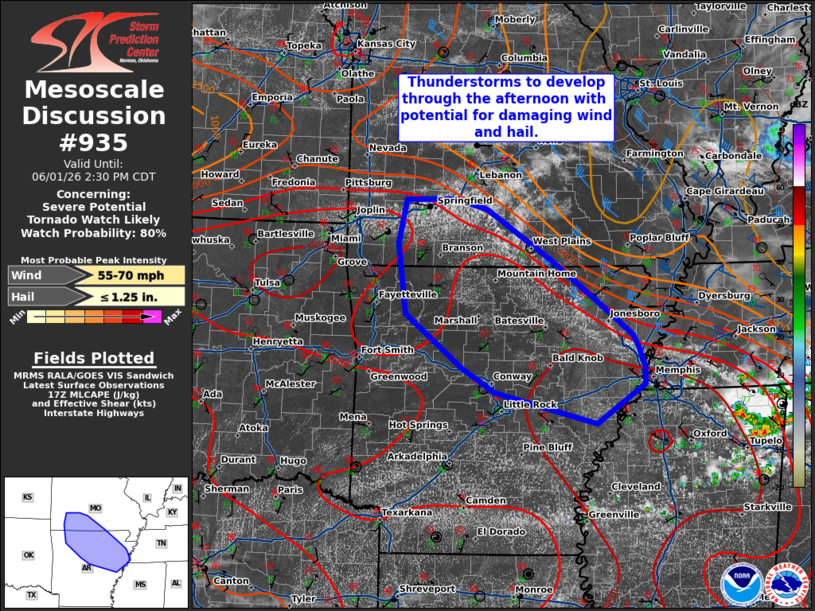
   Mesoscale Discussion 0935
   NWS Storm Prediction Center Norman OK
   1234 PM CDT Mon Jun 01 2026

   Areas affected...south-central Missouri...northern/central Arkansas

   Concerning...Severe potential...Severe Thunderstorm Watch likely

   Valid 011734Z - 011930Z

   CORRECTED FOR WATCH TYPE

   Probability of Watch Issuance...80 percent

   SUMMARY...Thunderstorm development is likely over the next 1-2
   hours. Hazards will include damaging winds and hail.

   DISCUSSION...An outflow boundary continues to sag south and westward
   across south-central MO into northern AR this afternoon. Cumulus
   development along this boundary has become increasingly agitated
   over the last hour. Thunderstorm development is likely over the next
   1-2 hours near this boundary. The environment ahead of this boundary
   is very hot and unstable with temperatures in the mid to upper 80s
   to low 90s and dew points in the low to mid 70s. Low-level lapse
   rates have been steepening, with around 7-7.5 C/km analyzed in
   surface objective analysis. Though deep layer flow is generally
   weak, this environment will favor multi-cell clusters with strong to
   severe winds and potential for small to marginally severe hail. A
   watch will likely be needed soon.

   ..Thornton/Mosier.. 06/01/2026

   ...Please see www.spc.noaa.gov for graphic product...

   ATTN...WFO...MEG...LZK...SGF...TSA...

   LAT...LON   37329295 37309372 36779383 35929371 35269286 34969238
               34599087 35079015 35279015 35519024 35679033 35999075
               36579155 37189249 37329295

   MOST PROBABLE PEAK WIND GUST...55-70 MPH
   MOST PROBABLE PEAK HAIL SIZE...UP TO 1.25 IN
|
|
|
Top/All Mesoscale Discussions/Forecast Products/Home |
|
Source link