|
|
| Mesoscale Discussion 928 | |
| < Previous MD Next MD > | |

|
|
   Mesoscale Discussion 0928
   NWS Storm Prediction Center Norman OK
   1156 AM CDT Fri May 24 2024

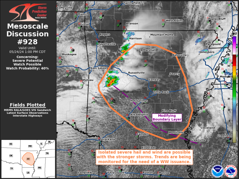
   Areas affected...portions of central and northern Arkansas

   Concerning...Severe potential...Watch possible

   Valid 241656Z - 241800Z

   Probability of Watch Issuance...40 percent

   SUMMARY...Some severe hail or wind may accompany the stronger storms
   that may try to become established over central and northern AR this
   afternoon. A WW issuance is possible.

   DISCUSSION...Thunderstorms have been percolating in intensity across
   west-central AR over the past couple of hours, with at least one
   report of 0.75 inch hail received. While earlier storms had
   overturned the airmass, ample insolation and low-level warm-air
   advection is supporting rapid modification of the boundary layer.
   RAP forecast soundings and mesoanalysis show 7-8 C/km mid-level
   lapse rates quickly ushering into AR from the west, which will
   further boost instability. Surface temperatures in the low 80s amid
   70+ F dewpoints should yield over 2000 J/kg MLCAPE amid 40-50 kts of
   effective bulk shear (characterized by elongated hodographs with
   modest low-level curvature). Multicells and perhaps a few supercell
   structures are possible this afternoon, with severe hail and wind
   gusts the main threats, though a tornado cannot be completely ruled
   out. A WW issuance may be needed pending convective trends.

   ..Squitieri/Guyer.. 05/24/2024

   ...Please see www.spc.noaa.gov for graphic product...

   ATTN...WFO...MEG...JAN...LZK...TSA...

   LAT...LON   35539370 35889322 36129286 36099216 35869152 35189117
               34279096 33869112 33519150 33469181 33789281 34369369
               34839408 34979410 35539370
|
|
|
Top/All Mesoscale Discussions/Forecast Products/Home |
|


