| Mesoscale Discussion 923 | |
| < Previous MD Next MD > | |

|
|
Mesoscale Discussion 0923
NWS Storm Prediction Center Norman OK
0507 PM CDT Sun May 31 2026
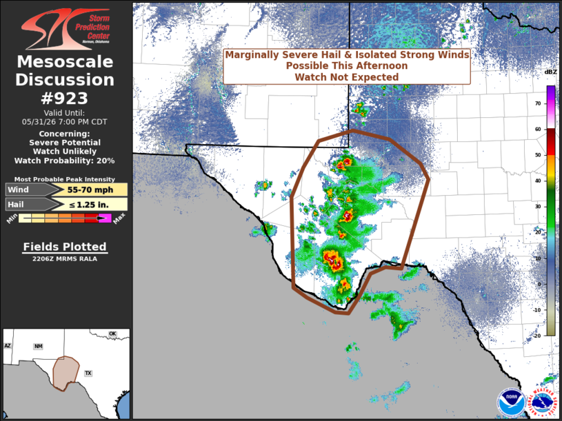
Areas affected...Southwest Texas
Concerning...Severe potential...Watch unlikely
Valid 312207Z - 010000Z
Probability of Watch Issuance...20 percent
SUMMARY...Marginally severe thunderstorms will be possible this
afternoon across portions of southwest Texas. The most likely hazard
will be strong gusty outflow winds with collapsing updrafts, but a
few large hail reports may be possible with the strongest updrafts.
A watch is not expected.
DISCUSSION...Strong diurnal heating and weak large-scale ascent from
a subtle low-latitude short-wave trough have combined to support
thunderstorm development this afternoon across portions of southwest
Texas. The thermodynamic environment across the area is
characterized by MUCAPE values between 1000-2000 J/kg, with most
storms developing near the higher MUCAPE values across the eastern
portion of the highlighted area. Kinematically speaking, the overall
environment is rather unfavorable for organized, sustained severe
thunderstorms, with deep-layer shear generally less than 25 knots.
Given storm development within an environment an uncapped
environment with MUCAPE values approaching 2000 J/kg and steep low-
and mid-level lapse rates, marginally severe thunderstorms are
possible this afternoon. The degree of instability and
steep-mid-level lapse rates suggests the potential for marginally
severe hail with the strongest updraft cores, and the steep
low-level lapse rates should support strong thunderstorm outflows,
especially with any collapsing core.
The overall severe threat should remain fairly isolated, thus a
watch is not anticipated.
..Marsh/Guyer.. 05/31/2026
...Please see www.spc.noaa.gov for graphic product...
ATTN...WFO...EWX...SJT...MAF...
LAT...LON 29370422 31050430 31620404 32120372 32320296 32140216
31690148 31390131 29730193 29750227 29640258 29200284
28900306 28910333 29180393 29370422
MOST PROBABLE PEAK WIND GUST...55-70 MPH
MOST PROBABLE PEAK HAIL SIZE...UP TO 1.25 IN
|
|
|
Top/All Mesoscale Discussions/Forecast Products/Home |
|
Source link