| Mesoscale Discussion 918 | |
| < Previous MD | |

|
|
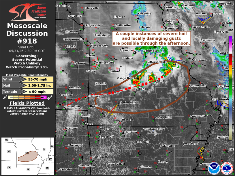
   Mesoscale Discussion 0918
   NWS Storm Prediction Center Norman OK
   1154 AM CDT Sun May 31 2026

   Areas affected...Portions of central and southern MO

   Concerning...Severe potential...Watch unlikely

   Valid 311654Z - 311930Z

   Probability of Watch Issuance...20 percent

   SUMMARY...A couple instances of severe hail and locally damaging
   wind gusts are possible through the afternoon.

   DISCUSSION...Thunderstorm clusters evolving along/immediately north
   of convective outflow spreading into central/southern MO are
   beginning to impinge on a moist, diurnally destabilizing PBL. Steep
   midlevel lapse rates (sampled by the 12Z SGF sounding) atop lower
   70s dewpoints will yield a strongly unstable air mass with continued
   diurnal heating this afternoon. This, combined with around 30 kt of
   effective shear (slightly enhanced by a convectively augmented
   midlevel impulse to the north), will support loosely organized
   clusters through the afternoon. The stronger storms will be capable
   of producing isolated severe hail and locally damaging wind gusts.
   Additional isolated storm development is possible along the trailing
   outflow boundary in southwest MO this afternoon, though weak
   large-scale forcing for ascent limits this confidence in this
   scenario.

   ..Weinman/Thompson.. 05/31/2026

   ...Please see www.spc.noaa.gov for graphic product...

   ATTN...WFO...LSX...SGF...

   LAT...LON   38139293 38579191 38689139 38639091 38469051 38029034
               37589050 37249095 36969168 36849262 36889379 37109424
               37389442 37579436 37689394 38139293

   MOST PROBABLE PEAK TORNADO INTENSITY...UP TO 90 MPH
   MOST PROBABLE PEAK WIND GUST...55-70 MPH
   MOST PROBABLE PEAK HAIL SIZE...1.00-1.75 IN
|
|
|
Top/All Mesoscale Discussions/Forecast Products/Home |
|
Source link