| Mesoscale Discussion 914 | |
| < Previous MD | |

|
|
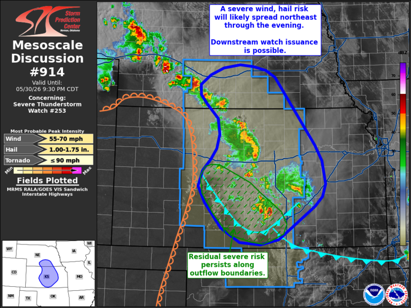
Mesoscale Discussion 0914 NWS Storm Prediction Center Norman OK 0729 PM CDT Sat May 30 2026 Areas affected...Central Kansas into south-central Nebraska Concerning...Severe Thunderstorm Watch 253... Valid 310029Z - 310230Z The severe weather threat for Severe Thunderstorm Watch 253 continues. SUMMARY...The threat for severe wind and hail continues across portions of central Kansas and south-central Nebraska, including behind the primary band of thunderstorms where new convection is developing along outflow boundaries. Trends are being monitored for the need for downstream watch issuance. DISCUSSION...Several severe wind reports have been noted over the past two hours across central KS as two predominant bands/clusters of thunderstorms have emerged and spread northeast. These clusters currently reside within the axis of higher MLCAPE and should be migrating towards a region of lower buoyancy across eastern NE and far eastern KS (as depicted by the recent 00z TOP RAOB that sampled around 1800 J/kg MLCAPE along with nearly -120 J/kg MLCIN). However, the presence of established cold pools with both clusters, combined with the coming onset of the nocturnal jet, may promote a continued severe wind threat downstream across southeast NE and parts of eastern Kansas through late evening. Convective trends will continue to be monitored for the need for downstream watch issuance. Further southwest across south-central KS, convection continues to develop along the outflow boundaries associated with the initial thunderstorm clusters. Although storm motions will be towards the convectively overturned/cold pool air, convective intensity trends in GOES cloud-top temperatures and MRMS VIL suggest that pockets of sufficient buoyancy remain in place for at least a localized hail and wind threat over the next couple of hours - especially as isentropic upglide over the cold pools increases with the onset of the nocturnal jet. ..Moore.. 05/31/2026 ...Please see www.spc.noaa.gov for graphic product... ATTN...WFO...OAX...TOP...ICT...GID...DDC... LAT...LON 37179753 37069803 37129860 37429911 37989955 38339974 38669961 38919940 39139923 39449915 39799921 40109953 40309969 40519969 40739942 40889905 40959860 40909822 40839787 40679762 39219652 38879634 38379624 38109634 37889654 37179753 MOST PROBABLE PEAK TORNADO INTENSITY...UP TO 90 MPH MOST PROBABLE PEAK WIND GUST...55-70 MPH MOST PROBABLE PEAK HAIL SIZE...1.00-1.75 IN |
|
|
Top/All Mesoscale Discussions/Forecast Products/Home |
|
Source link