| Mesoscale Discussion 906 | |
| < Previous MD | |

|
|
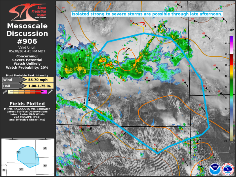
   Mesoscale Discussion 0906
   NWS Storm Prediction Center Norman OK
   0321 PM CDT Sat May 30 2026

   Areas affected...Parts of eastern MT...northeast WY...southwest
   ND...northwest SD

   Concerning...Severe potential...Watch unlikely

   Valid 302021Z - 302245Z

   Probability of Watch Issuance...20 percent

   SUMMARY...Isolated strong to severe storms are possible through late
   afternoon.

   DISCUSSION...Occasionally strong storms are ongoing this afternoon
   across eastern MT, to the northeast of a negative-tilt mid/upper
   shortwave trough approaching the central/northern High Plains. This
   convection is ongoing within a weak to moderately unstable
   environment, with generally limited deep-layer shear. Storms in this
   area may tend to remain disorganized through the afternoon, though
   marginally severe hail and localized strong gusts cannot be ruled
   out in the near term.

   In the wake of this convection, diurnal heating is underway from
   northeast WY/southeast MT into northwest SD/southwest ND, where
   somewhat stronger instability will evolve by late afternoon. Renewed
   storm initiation will be possible with time, with the highest
   confidence in redevelopment near the Big Horns and northern parts of
   the Black Hills. Deep-layer shear will generally remain modest, but
   a few stronger multicells could develop, accompanied by an isolated
   hail threat. Increasingly prominent outflow may also lead to
   localized strong to severe gusts, especially if any stronger
   clusters or line segments evolve with time.

   ..Dean/Hart.. 05/30/2026

   ...Please see www.spc.noaa.gov for graphic product...

   ATTN...WFO...BIS...UNR...BYZ...GGW...RIW...

   LAT...LON   45160752 45600863 46930848 47620777 47890609 47730487
               47400442 46400349 45630335 44930323 44720353 44560427
               44360502 44150550 44320584 45160752

   MOST PROBABLE PEAK WIND GUST...55-70 MPH
   MOST PROBABLE PEAK HAIL SIZE...1.00-1.75 IN
|
|
|
Top/All Mesoscale Discussions/Forecast Products/Home |
|
Source link