| Mesoscale Discussion 904 | |
| < Previous MD | |

|
|
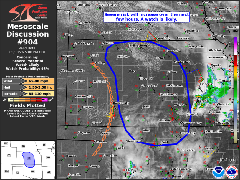
   Mesoscale Discussion 0904
   NWS Storm Prediction Center Norman OK
   0228 PM CDT Sat May 30 2026

   Areas affected...Much of central Kansas and north-central Oklahoma

   Concerning...Severe potential...Watch likely

   Valid 301928Z - 302200Z

   Probability of Watch Issuance...95 percent

   SUMMARY...The severe risk will increase over the next few hours
   before spreading east-northeastward through late afternoon into this
   evening. The primary concerns will be large hail and scattered
   severe gusts.

   DISCUSSION...The latest visible satellite imagery shows an expanding
   cumulus field behind the dryline in southwest KS, with isolated
   towers beginning to develop within the dryline circulation. As
   temperatures continue to climb into the middle 90s along/west of the
   dryline, the deepening circulation should promote isolated to widely
   scattered thunderstorm development over the next few hours. Despite
   somewhat modest deep-layer shear (around 25-35 kt of effective
   shear), steep lapse rates atop a moist boundary layer (upper 60s
   dewpoints) are contributing to a strongly unstable warm sector --
   favorable for quickly intensifying updrafts and robust downdrafts.
   The early stages of convective development/intensification should be
   characterized by a mix of semi-discrete supercells and organized
   clusters -- both posing a risk of large hail and severe wind gusts.

   With time, an increase in thunderstorm coverage is expected along
   the dryline and expanding cold pools, which will favor a band of
   upscale-growing clusters and strengthening outflow within an axis of
   (~4000 J/kg MLCAPE). This evolution will promote scattered severe
   wind gusts with east-northeastward extent across central KS. A
   gradually strengthening nocturnal LLJ will yield expanding low-level
   hodographs and some increase in tornado potential this evening.
   However, the aforementioned mode evolution limits confidence in the
   overall risk.

   While timing of convective development and maturation is a bit
   uncertain, a watch issuance is likely.

   ..Weinman/Hart.. 05/30/2026

   ...Please see www.spc.noaa.gov for graphic product...

   ATTN...WFO...TSA...TOP...ICT...OUN...GID...DDC...GLD...

   LAT...LON   36359813 36499898 36889941 37479967 38779990 39360036
               39710029 39909996 39989922 39969832 39759764 39479721
               38799676 37409657 36759673 36399723 36359813

   MOST PROBABLE PEAK TORNADO INTENSITY...85-110 MPH
   MOST PROBABLE PEAK WIND GUST...65-80 MPH
   MOST PROBABLE PEAK HAIL SIZE...1.50-2.50 IN
|
|
|
Top/All Mesoscale Discussions/Forecast Products/Home |
|
Source link