| Mesoscale Discussion 903 | |
| < Previous MD | |

|
|
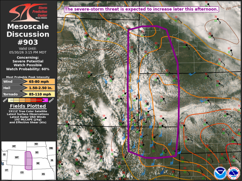
   Mesoscale Discussion 0903
   NWS Storm Prediction Center Norman OK
   0214 PM CDT Sat May 30 2026

   Areas affected...Parts of western NE/SD into northeast CO and
   extreme eastern WY

   Concerning...Severe potential...Watch possible

   Valid 301914Z - 302115Z

   Probability of Watch Issuance...60 percent

   SUMMARY...The severe-storm threat is expected to increase later this
   afternoon. Watch issuance is possible.

   DISCUSSION...A negative-tilt mid/upper-level shortwave trough across
   the central/northern Rockies will move east-northeastward toward the
   High Plains through the afternoon. Southeasterly flow will maintain
   low-level moisture transport into parts of western NE/SD and
   adjacent northeast CO/eastern WY, to the north of a surface low near
   the CO/KS border. Modest diurnal heating and steep midlevel lapse
   rates are supporting MLCAPE of 1000-2000 J/kg, with locally greater
   values across southwest NE.

   The approaching shortwave trough will aid in scattered storm
   development from late afternoon into the evening. Initial
   development is ongoing in the Black Hills vicinity, and additional
   storms may develop near a surface trough extending northward from
   the surface low into northeast CO and the NE/CO/WY border region.
   Deep-layer flow will remain generally modest, though some
   enhancement to effective shear/SRH will be possible near any surface
   boundaries and where stronger backing of low-level flow occurs.

   Organized multicells and perhaps a couple supercells may evolve with
   time, with an attendant threat of large hail and localized severe
   gusts. The thermodynamic environment is conditionally favorable for
   very large hail (especially across parts of western NE and northeast
   CO), if any supercells can be sustained. A tornado or two also
   cannot be ruled out, especially where low-level vorticity is
   enhanced near any surface boundaries and the DCVZ. Watch issuance is
   possible for parts of the region by mid/late afternoon.

   ..Dean/Hart.. 05/30/2026

   ...Please see www.spc.noaa.gov for graphic product...

   ATTN...WFO...LBF...UNR...GLD...BOU...CYS...

   LAT...LON   40090452 42480460 44620460 44760389 44760310 44640262
               43380206 42410201 41250205 40640212 39900222 39830311
               39850371 40090452

   MOST PROBABLE PEAK TORNADO INTENSITY...85-110 MPH
   MOST PROBABLE PEAK WIND GUST...65-80 MPH
   MOST PROBABLE PEAK HAIL SIZE...1.50-2.50 IN
|
|
|
Top/All Mesoscale Discussions/Forecast Products/Home |
|
Source link