|
|
| Mesoscale Discussion 901 | |
| < Previous MD | |

|
|
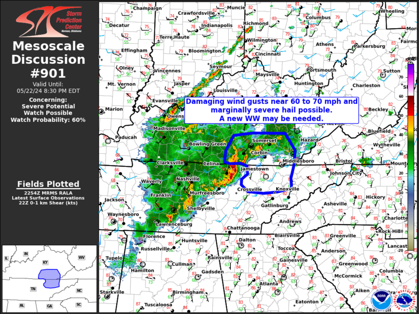
   Mesoscale Discussion 0901
   NWS Storm Prediction Center Norman OK
   0557 PM CDT Wed May 22 2024

   Areas affected...South-central Kentucky and northern middle
   Tennessee

   Concerning...Severe potential...Watch possible

   Valid 222257Z - 230030Z

   Probability of Watch Issuance...60 percent

   SUMMARY...Damaging wind gusts and marginally severe hail may
   accompany a  bowing line segment across north-central middle TN and
   south-central KY over the next 1-2 hours.

   DISCUSSION...Recent radar imagery shows a bowing segment with a
   descending RIJ progressing eastward across Overton County in TN.
   Confidence in this feature maintaining its intensity over the next
   few hours is low to moderate considering a weakly forced
   environment, increasing CINH through evening, and downstream
   low-level flow parallel to the convergence zone. Regardless,
   extrapolation of this features may require a short-fused downstream
   watch for damaging wind gusts up to 70 mph.

   ..Barnes/Thompson.. 05/22/2024

   ...Please see www.spc.noaa.gov for graphic product...

   ATTN...WFO...MRX...JKL...LMK...OHX...

   LAT...LON   35988469 36148488 36278486 36398469 36578472 36638489
               36628521 36668536 36928534 37288510 37358454 37348360
               36948332 36638363 36318362 36148371 35968385 35938423
               35988469
|
|
|
Top/All Mesoscale Discussions/Forecast Products/Home |
|