|
|
| Mesoscale Discussion 899 | |
| < Previous MD | |

|
|
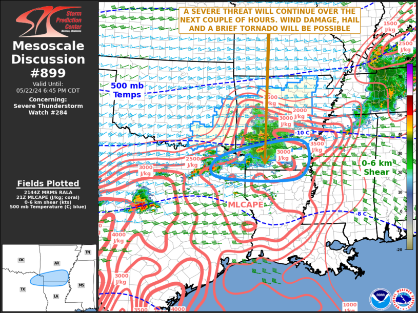
Mesoscale Discussion 0899 NWS Storm Prediction Center Norman OK 0447 PM CDT Wed May 22 2024 Areas affected...Northeast Texas...Southern Arkansas...Far Northern Louisiana Concerning...Severe Thunderstorm Watch 284... Valid 222147Z - 222345Z The severe weather threat for Severe Thunderstorm Watch 284 continues. SUMMARY...A severe threat is likely to continue for a few more hours from northeast Texas eastward into southern Arkansas and far northern Louisiana. Wind damage, hail and perhaps a tornado or two will be possible. A new watch is being issued for parts of the Ark-La-Tex. DISCUSSION...The latest radar imagery from Shreveport shows scattered strong to severe storms from northeast Texas into southwestern Arkansas, with a couple supercells ongoing. The storms are located near an axis of strong to extreme instability, where the RAP is estimated MLCAPE in the 4500 to 5500 J/kg range. In addition, the Little Rock and Shreveport WSR-88D VWPs have 0-6 km shear in the 50 to 60 knot range. Forecast soundings in the Ark-La-Tex have 700-500 mb lapse rates in the 8 to 8.5 C/km range. This enviroment will be favorable for supercells with large hail, and hailstones greater than 2 inches in diameter will be possible with the strongest of updrafts. Wind damage will be likely with supercells and the more intense line segments. Low-level shear will also be sufficient for a tornado or two. ..Broyles/Thompson.. 05/22/2024 ...Please see www.spc.noaa.gov for graphic product... ATTN...WFO...JAN...LZK...SHV...FWD... LAT...LON 34069276 34149188 34039140 33739123 33309123 32979137 32739165 32639220 32619362 32759526 33109554 33489516 33689460 33869389 34069276 |
|
|
Top/All Mesoscale Discussions/Forecast Products/Home |
|


