| Mesoscale Discussion 898 | |
| < Previous MD | |

|
|
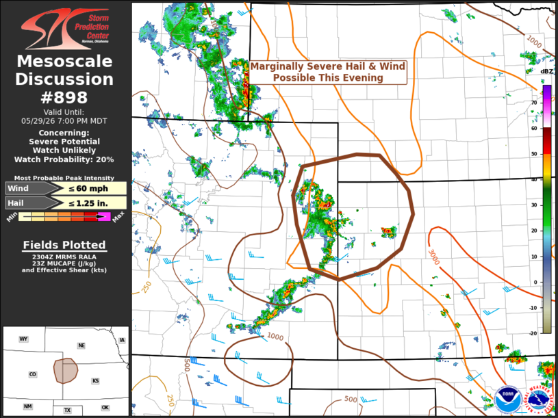
   Mesoscale Discussion 0898
   NWS Storm Prediction Center Norman OK
   0605 PM CDT Fri May 29 2026

   Areas affected...eastern Colorado...northwest Kansas...and extreme
   southwest Nebraska

   Concerning...Severe potential...Watch unlikely

   Valid 292305Z - 300100Z

   Probability of Watch Issuance...20 percent

   SUMMARY...Thunderstorms across the area will continue to pose a
   threat for marginally severe hail and wind. The threat should
   diminish later this evening with the loss of diurnal heating. A
   watch is not expected.

   DISCUSSION...A loosely organized cluster of multicell thunderstorms
   has developed across the plains of eastern Colorado. These storms
   appear to be in response to deep boundary layer circulations
   combining with modest large-scale ascent associated with the
   northern edge of a weak vorticity maximum moving within the broader
   mid-to-upper-level southwesterly flow.

   The thermodynamic environment is quite unstable, with objectively
   analyzed MUCAPE fields between 2000-3000 J/kg along and ahead of the
   cluster. Kinematically speaking, the environment is only marginally
   supportive of loosely organized multicell clusters given deep-layer
   shear generally between 20 and 30 knots.

   The degree of instability would support marginally severe hail.
   Recent observed dewpoint trends show decreasing surface dewpoint
   temperatures across the area, which would suggest steep
   low-level-lapse rates and strong vertical mixing. This dry sub-cloud
   layer should support some severe wind potential as well.

   If this cluster can sustain itself into the evening hours as it
   moves northeast, a brief uptick in severe potential will be possible
   around sunset as the nocturnal low-level wind maximum strengthens,
   increasing shear across the complex. However, thunderstorm intensity
   should generally wane with the loss of diurnal heating.

   A watch is not anticipated given the limited spatial and temporal
   threat. However, the area is being monitored.

   ..Marsh/Guyer.. 05/29/2026

   ...Please see www.spc.noaa.gov for graphic product...

   ATTN...WFO...LBF...DDC...GLD...PUB...BOU...

   LAT...LON   38520264 39280294 39770302 40260282 40470163 40440113
               40140077 39850050 39450041 38860068 38540120 38350202
               38520264

   MOST PROBABLE PEAK WIND GUST...UP TO 60 MPH
   MOST PROBABLE PEAK HAIL SIZE...UP TO 1.25 IN
|
|
|
Top/All Mesoscale Discussions/Forecast Products/Home |
|
Source link