| Mesoscale Discussion 897 | |
| < Previous MD Next MD > | |

|
|
Mesoscale Discussion 0897
NWS Storm Prediction Center Norman OK
0557 PM CDT Fri May 29 2026
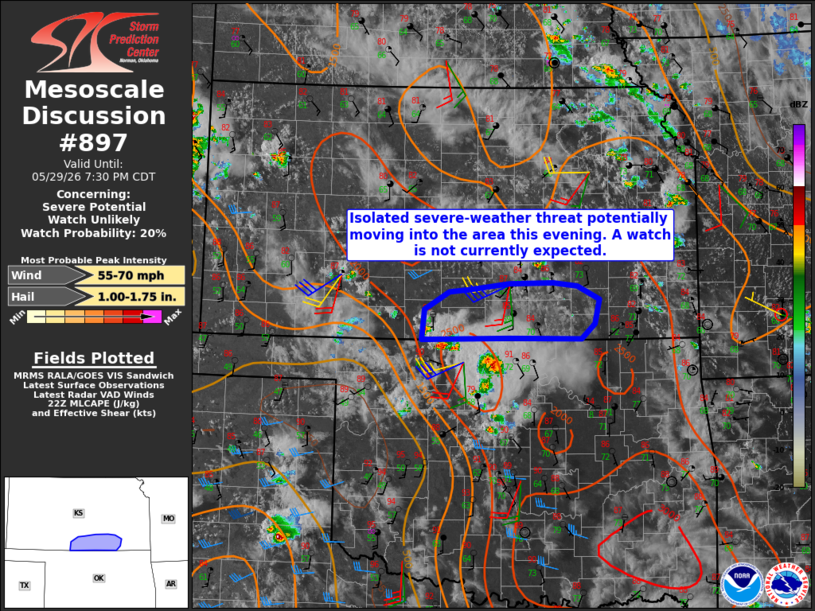
Areas affected...south-central Kansas
Concerning...Severe potential...Watch unlikely
Valid 292257Z - 300030Z
Probability of Watch Issuance...20 percent
SUMMARY...The potential for isolated occurrences of damaging winds
and/or large hail may increase this evening with storms moving into
the area from northern Oklahoma. Areal coverage is expected to
remain too limited for a watch issuance.
DISCUSSION...A cluster of severe thunderstorms ongoing across
portions of north-central and northwest OK being driven north by
convective outflow with a subset of that activity likely moving into
portions of south-central KS within the next 30-60 minutes.
Objective analysis suggests that the air mass across the discussion
area is moderate to strongly unstable with MLCAPE of 2000-3000 J/kg.
However, comparison of the KVNX and KICT VWPs indicates that already
marginal deep-layer shear in place across northern OK decreases
within northward extent into southern KS. So while the thermodynamic
environment will support the potential for locally severe wind gusts
and perhaps marginally severe hail across the discussion area, the
weak vertical shear is expected to limit the potential for a more
robust severe-weather threat.
..Mead/Guyer.. 05/29/2026
...Please see www.spc.noaa.gov for graphic product...
ATTN...WFO...ICT...OUN...DDC...
LAT...LON 36999874 37019746 37009637 37189616 37479610 37649642
37689679 37679744 37599802 37569834 37369870 36999874
MOST PROBABLE PEAK WIND GUST...55-70 MPH
MOST PROBABLE PEAK HAIL SIZE...1.00-1.75 IN
|
|
|
Top/All Mesoscale Discussions/Forecast Products/Home |
|
Source link