| Mesoscale Discussion 895 | |
| < Previous MD | |
|
|
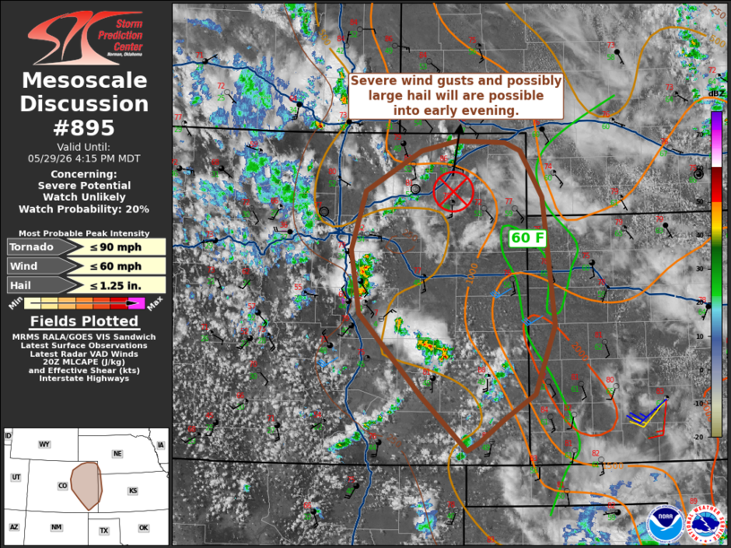
   Mesoscale Discussion 0895
   NWS Storm Prediction Center Norman OK
   0319 PM CDT Fri May 29 2026

   Areas affected...Front Range into far western Kansas

   Concerning...Severe potential...Watch unlikely

   Valid 292019Z - 292215Z

   Probability of Watch Issuance...20 percent

   SUMMARY...Severe wind gusts are possible into the early evening. A
   watch is not expected given limited coverage of severe activity.

   DISCUSSION...In the wake of an MCV in northeast Colorado, forcing
   for ascent from a shortwave trough pivoting through the eastern
   Great Basin has promoted thunderstorms development along parts of
   the Front Range into southeast Colorado. These storms have been able
   to move off the terrain into the eastern Plains. Outflow production
   with these storms is evident. VAD data from KFTG and KPUX show weak
   deep-layer shear (around 20 kt). A very well-mixed boundary layer
   exists in much of eastern Colorado. Severe gusts will likely be the
   primary risk with storms that develop this afternoon. Greater
   surface moisture does exist in western Kansas. Some intensification
   would be possible if storms can ingest more buoyant air. While large
   hail is possible with a discrete storm within the greater moisture,
   storm mode by that point may not be very favorable. A brief tornado
   could also occur given the presence of the MVC and DCVZ.

   ..Wendt/Hart.. 05/29/2026

   ...Please see www.spc.noaa.gov for graphic product...

   ATTN...WFO...LBF...DDC...GLD...PUB...BOU...

   LAT...LON   38810466 39590478 40300456 40790369 40910314 40880238
               40790214 40220180 38680162 37840193 37540243 37270279
               37170299 37820369 38810466

   MOST PROBABLE PEAK TORNADO INTENSITY...UP TO 90 MPH
   MOST PROBABLE PEAK WIND GUST...UP TO 60 MPH
   MOST PROBABLE PEAK HAIL SIZE...UP TO 1.25 IN
|
|
|
Top/All Mesoscale Discussions/Forecast Products/Home |
|
Source link