| Mesoscale Discussion 893 | |
| < Previous MD | |
|
|
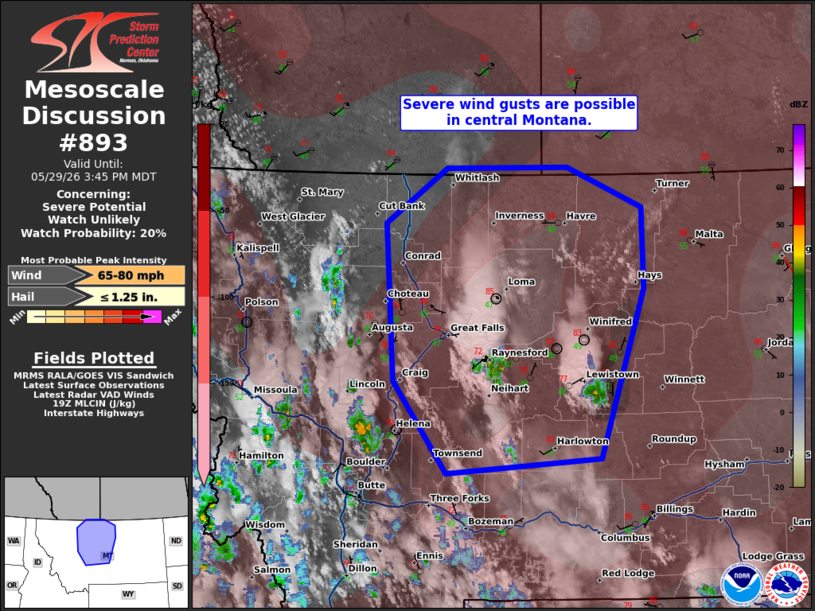
   Mesoscale Discussion 0893
   NWS Storm Prediction Center Norman OK
   0251 PM CDT Fri May 29 2026

   Areas affected...Central Montana

   Concerning...Severe potential...Watch unlikely

   Valid 291951Z - 292145Z

   Probability of Watch Issuance...20 percent

   SUMMARY...Severe wind gusts along with small to marginally severe
   hail may occur this afternoon/evening in central Montana. Storm
   coverage is expected to limit a more organized severe wind threat. A
   watch is not anticipated at this time.

   DISCUSSION...While some MLCIN remains within the plains, convection
   continues to develop/deepen on the higher terrain of central
   Montana. The 18Z observed Great Falls sounding showed nearly dry
   adiabatic mid-level lapse rates. When modifying the sounding for
   current surface observations, low-level lapse rates are also
   similarly steep. That said, the boundary layer is quite dry and
   dewpoints have since mixed down into the upper 40s F. With
   additional surface heating, the expectation is for thunderstorms to
   move north/north-northeast off of the terrain. Severe wind gusts
   will be the primary hazard with this activity. Small hail is also
   possible, though a stronger core could produce marginally severe
   hail. Storm coverage is uncertain given weak large-scale ascent. Any
   greater severe wind threat would be dependent on localized
   clustering of storms/outflow.

   ..Wendt/Hart.. 05/29/2026

   ...Please see www.spc.noaa.gov for graphic product...

   ATTN...WFO...BYZ...GGW...TFX...

   LAT...LON   46181131 47061205 48531217 49061133 49070964 48690859
               47920857 46330918 46181131

   MOST PROBABLE PEAK WIND GUST...65-80 MPH
   MOST PROBABLE PEAK HAIL SIZE...UP TO 1.25 IN
|
|
|
Top/All Mesoscale Discussions/Forecast Products/Home |
|
Source link