| Mesoscale Discussion 889 | |
| < Previous MD | |

|
|
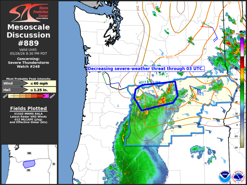
Mesoscale Discussion 0889 NWS Storm Prediction Center Norman OK 0853 PM CDT Thu May 28 2026 Areas affected...north-central Oregon Concerning...Severe Thunderstorm Watch 248... Valid 290153Z - 290330Z The severe weather threat for Severe Thunderstorm Watch 248 continues. SUMMARY...While isolated occurrences of marginally severe hail and/or damaging winds remain possible, an overall decrease in storm intensity is expected through 03 UTC. Remaining valid portions of the watch will likely be allowed to expire at that time. DISCUSSION...A cluster of strong thunderstorms is ongoing as of 01:45 UTC across a small part of north-central OR, namely Morrow and Gilliam Counties. Latest objective analysis suggests that the local environment remains at least marginally unstable with increasing convective inhibition. As such, the expectation is for a gradual decrease in storm intensity through 03 UTC. Prior to the time, constructive storm interactions could lead to periods of intensification, with an associated risk for marginally severe hail and/or wind gusts. Should current storm trends continue, the remaining valid portion of Severe Thunderstorm Watch 248 will likely be allowed to expire at 03 UTC. ..Mead.. 05/29/2026 ...Please see www.spc.noaa.gov for graphic product... ATTN...WFO...PDT...PQR... LAT...LON 45841955 45341944 45101967 44952059 44832120 45272158 45572150 45712118 45782021 45841955 MOST PROBABLE PEAK WIND GUST...UP TO 60 MPH MOST PROBABLE PEAK HAIL SIZE...UP TO 1.25 IN |
|
|
Top/All Mesoscale Discussions/Forecast Products/Home |
|
Source link