| Mesoscale Discussion 881 | |
| < Previous MD | |

|
|
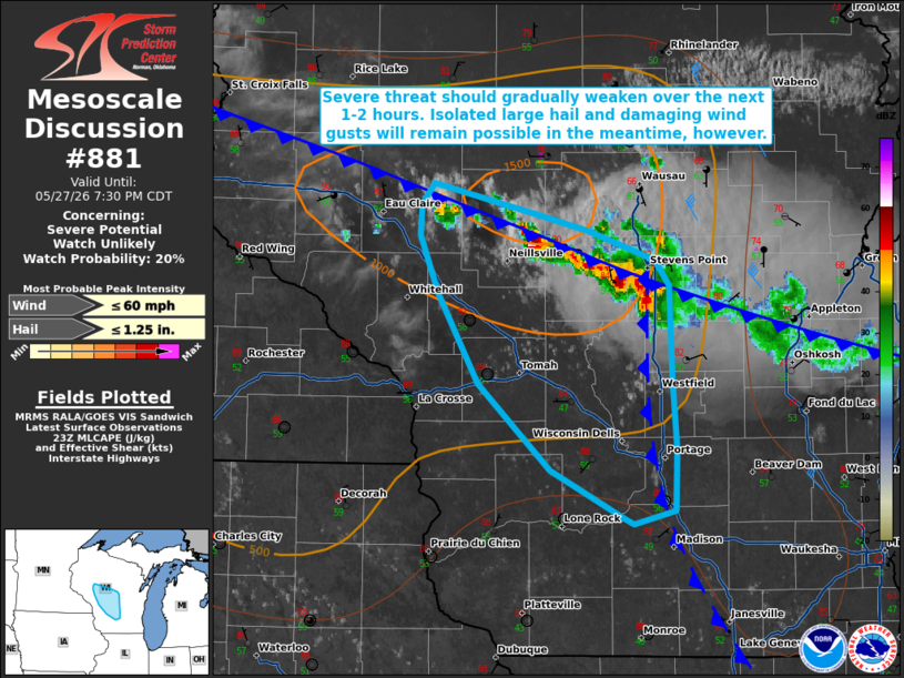
   Mesoscale Discussion 0881
   NWS Storm Prediction Center Norman OK
   0607 PM CDT Wed May 27 2026

   Areas affected...portions of central Wisconsin

   Concerning...Severe potential...Watch unlikely

   Valid 272307Z - 280030Z

   Probability of Watch Issuance...20 percent

   SUMMARY...The severe risk associated with an ongoing multicell
   cluster across central Wisconsin should gradually decrease over the
   next 1-2 hours. Isolated large hail and damaging wind gusts remain
   possible in the meantime, however.

   DISCUSSION...A multicell cluster with a embedded supercell
   structures continues to track southward along and west of the I-39
   corridor in central Wisconsin having produced several reports of
   hail up to 2" in diameter and damaging wind gusts in the Wausau,
   Wisconsin, vicinity over the past 1-2 hours. Expectation is for this
   cluster to persist for another hour or two as it propagates
   southward along an east-west oriented cold front and to the west of
   a weak, north-south oriented lake breeze. Latest objective analysis
   indicates that available buoyancy generally decreases with southward
   extent. Coupled with the gradual onset of nocturnal low-level
   cooling/stabilization, this should yield a gradual weakening of this
   cluster with time. Modestly steep mid-level lapse rates and around
   30 kts of effective shear amid moderately strong northwesterly flow
   aloft (as sampled by the GRB VWP) will continue to promote a risk
   for large hail with the strongest updrafts in the meantime, however.
   Steep low-level lapse rates west of the lake breeze boundary will
   also support a continued threat for isolated damaging wind gusts.

   ..Chalmers/Guyer.. 05/27/2026

   ...Please see www.spc.noaa.gov for graphic product...

   ATTN...WFO...GRB...MKX...ARX...MPX...

   LAT...LON   43228974 43479027 43929079 44389109 44699122 44859120
               44969112 44859060 44799038 44718998 44558952 44438942
               43948939 43578936 43268937 43188967 43228974

   MOST PROBABLE PEAK WIND GUST...UP TO 60 MPH
   MOST PROBABLE PEAK HAIL SIZE...UP TO 1.25 IN
|
|
|
Top/All Mesoscale Discussions/Forecast Products/Home |
|
Source link