| Mesoscale Discussion 880 | |
| < Previous MD Next MD > | |

|
|
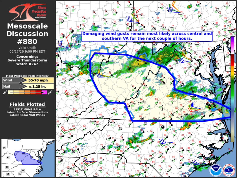
Mesoscale Discussion 0880 NWS Storm Prediction Center Norman OK 0554 PM CDT Wed May 27 2026 Areas affected...West Virginia into central and southern parts of Virginia Concerning...Severe Thunderstorm Watch 247... Valid 272254Z - 280100Z The severe weather threat for Severe Thunderstorm Watch 247 continues. SUMMARY...Isolated damaging wind gusts remain most likely across portions of central and southern Virginia over the next couple of hours. DISCUSSION...As of 22:45 UTC a broken band of strong to severe storms was ongoing from northeast of Roanoke to west of Richmond, with a storm motion of 282/38 kt. Latest surface analysis and visible satellite indicate a corridor of less-dense cloud cover to the south of the ongoing storms, where temperatures remain in the low/mid 80s with dewpoints in the upper 60s to low 70s. Resultant MLCAPE is estimated in the 1000-1500 J/kg range within that corridor with relatively steep low-level lapse rates. Area VWPs indicate westerly winds above 1 km AGL with 30-35 kt of deep-layer shear, which will continue to support some storm organization for the next couple of hours with the primary hazard being locally damaging wind gusts. Cooling boundary-layer temperatures and a corresponding increase in air mass stability are expected to lead to an increasingly sporadic severe threat by 01z. ..Mead.. 05/27/2026 ...Please see www.spc.noaa.gov for graphic product... ATTN...WFO...AKQ...LWX...RAH...RNK...RLX...JKL...ILN... LAT...LON 36538052 37248091 37268172 37708227 38348270 38928276 39248252 39248171 39218081 38917955 38687880 38237835 38017838 37797834 37657782 37537723 37317642 37137598 36927550 36617555 36487699 36538052 MOST PROBABLE PEAK WIND GUST...55-70 MPH MOST PROBABLE PEAK HAIL SIZE...UP TO 1.25 IN |
|
|
Top/All Mesoscale Discussions/Forecast Products/Home |
|
Source link