| Mesoscale Discussion 879 | |
| < Previous MD | |

|
|
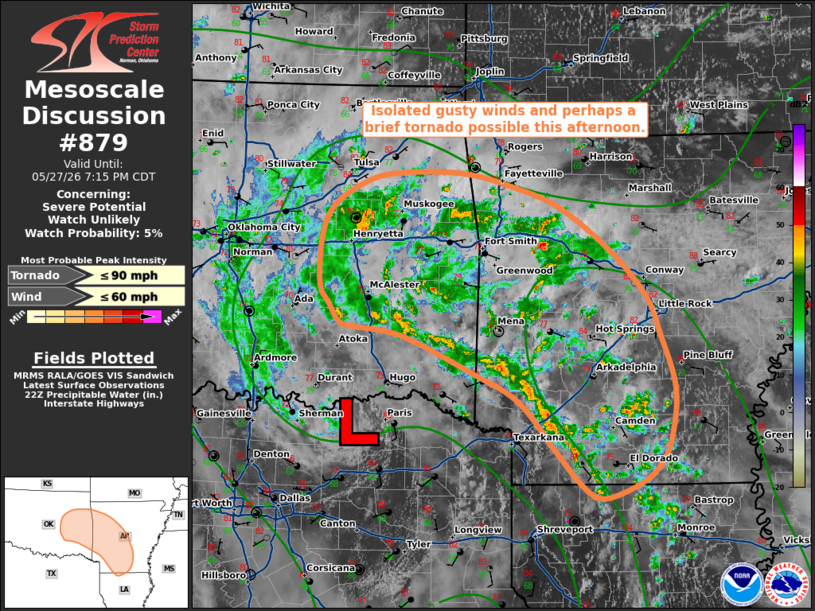
   Mesoscale Discussion 0879
   NWS Storm Prediction Center Norman OK
   0508 PM CDT Wed May 27 2026

   Areas affected...portion of eastern Oklahoma into central/southern
   Arkansas

   Concerning...Severe potential...Watch unlikely

   Valid 272208Z - 280015Z

   Probability of Watch Issuance...5 percent

   SUMMARY...A few strong thunderstorms may bring a low-end risk for
   isolated gusty winds and perhaps a brief tornado through this
   evening. Watch issuance is not expected.

   DISCUSSION...As of 2200 UTC, regional radar imagery depicted
   scattered thunderstorms extending from eastern Oklahoma into
   central/southern Arkansas immediately downstream of a mid-level
   perturbation and in close proximity to a surface low analyzed near
   the Red River. A couple of storms have shown signs of transient,
   weak rotation and/or modestly enhanced velocity signatures over the
   past hour. Expectation is for this activity to continue for another
   few hours amid a moist and weak to modestly unstable environment
   (MLCAPE of 1000-1500+ J/kg). While marginal deep-layer shear
   (generally less than 30 kts) and poor mid-level lapse rates, as
   sampled by the 18z SHV observed sounding, are largely expected to
   temper updraft intensity, high precipitable water contents
   (1.75-2.00+ inches per latest mesoanalysis) may promote occasional
   water-loaded downdrafts capable of isolated gusty winds (largely in
   the 40-45 mph range). A brief tornado also cannot be ruled out,
   especially where a stronger low-level updraft can interact with
   marginally enhanced low-level shear to the north-northeast of the
   surface low. Given the expectation for any severe threat to remain
   isolated and limited in magnitude, a WW is unlikely.

   ..Chalmers/Guyer.. 05/27/2026

   ...Please see www.spc.noaa.gov for graphic product...

   ATTN...WFO...LZK...SHV...TSA...OUN...

   LAT...LON   33349352 33839395 34119450 34489535 34579588 34629611
               34819626 34999637 35449636 35759624 35989594 36129550
               36139465 35989397 35779343 35329282 34899240 34529225
               33969207 33469212 33199226 33029250 32879294 33009321
               33349352

   MOST PROBABLE PEAK TORNADO INTENSITY...UP TO 90 MPH
   MOST PROBABLE PEAK WIND GUST...UP TO 60 MPH
|
|
|
Top/All Mesoscale Discussions/Forecast Products/Home |
|
Source link