| Mesoscale Discussion 877 | |
| < Previous MD Next MD > | |
|
|
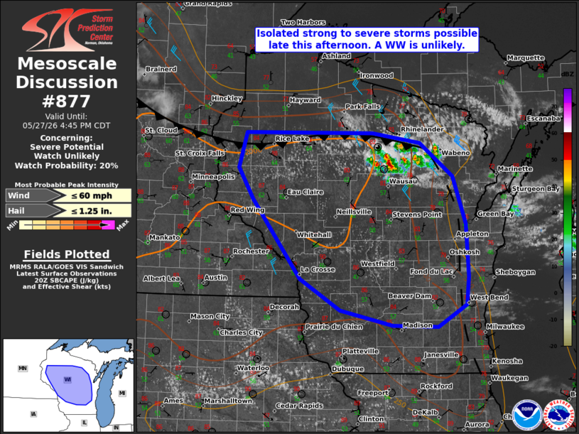
   Mesoscale Discussion 0877
   NWS Storm Prediction Center Norman OK
   0314 PM CDT Wed May 27 2026

   Areas affected...central Wisconsin

   Concerning...Severe potential...Watch unlikely

   Valid 272014Z - 272145Z

   Probability of Watch Issuance...20 percent

   SUMMARY...Strong to severe storms may pose a risk for isolated hail
   or damaging gusts this afternoon and evening.

   DISCUSSION...As of 2010 UTC, visible imagery showed thunderstorms
   developing along a southward moving cold front over portions of
   northern WI. Strong heating of a modestly moist air mass ahead of
   the front has resulted in weak to moderate instability (SBCAPE
   1000-2000 J/kg) amid steep low and mid-level lapse rates. Continued
   heating and weak ascent from an upper trough over the Great Lakes
   will aid in continued storm development along the front. Flow aloft
   is not overly strong, but area RAP soundings show 25-35 kt of
   deep-layer shear which could allow for modest storm organization.
   The stronger updrafts will be capable of hail, with steep lapse
   rates in the lowest few km potentially supporting damaging gusts.

   The initial storms, likely multi cellular, should gradually mature
   this afternoon given the buoyancy and steep lapse rates.  While
   shear is not overly strong, a few transient supercell structures
   will also be possible. Hail and damaging gusts may occur with these
   storms, but the lack of stronger ascent should limit coverage and
   organization, keeping the threat isolated. A WW is unlikely.

   ..Lyons/Gleason.. 05/27/2026

   ...Please see www.spc.noaa.gov for graphic product...

   ATTN...WFO...GRB...MKX...DLH...ARX...MPX...

   LAT...LON   45649223 45648990 45528903 45078844 44468821 43768816
               43398821 43118873 43138955 43329049 43749123 44779210
               45189236 45649223

   MOST PROBABLE PEAK WIND GUST...UP TO 60 MPH
   MOST PROBABLE PEAK HAIL SIZE...UP TO 1.25 IN
|
|
|
Top/All Mesoscale Discussions/Forecast Products/Home |
|
Source link