| Mesoscale Discussion 876 | |
| < Previous MD | |
|
|
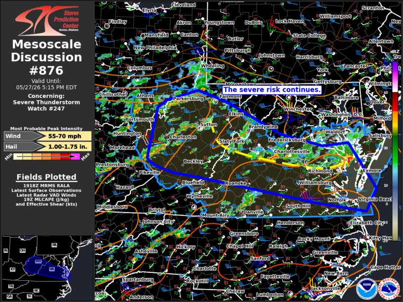
Mesoscale Discussion 0876 NWS Storm Prediction Center Norman OK 0221 PM CDT Wed May 27 2026 Areas affected...portions of the upper Ohio Valley...West Virginia...and the Mid Atlantic Concerning...Severe Thunderstorm Watch 247... Valid 271921Z - 272115Z The severe weather threat for Severe Thunderstorm Watch 247 continues. SUMMARY...The severe risk continues across WW247. Several stronger clusters of storms have also been identified. DISCUSSION...Afternoon radar imagery over WW247 showed scattered to numerous thunderstorms ongoing over the watch area. The environment remains unstable and modestly sheared, which should continue to support the threat for damaging gusts and some hail with the strongest storms over much of the watch area. A corridor of locally greater severe potential is now apparent along a convectively modified boundary stretching from central VA northwestward into WV. Several clusters of stronger storms, including a supercell crossing the Chesapeake Bay, have become established along the boundary. The most unstable air mass (MLCAPE 1500-2000 J/kg) and slightly stronger flow aloft resides along and south of the boundary, where locally enhanced convergence is also supporting an increase in convective coverage. This will likely support a few more robust storms with a concentrated risk for damaging gusts from southern WV into south central VA over the next few hours. ..Lyons.. 05/27/2026 ...Please see www.spc.noaa.gov for graphic product... ATTN...WFO...AKQ...LWX...RNK...PBZ...RLX... LAT...LON 37938226 39128199 39318169 39568075 39468042 39267982 38527824 38237697 38297619 37187538 36647571 36867713 37498079 37588143 37708192 37848218 37938226 MOST PROBABLE PEAK WIND GUST...55-70 MPH MOST PROBABLE PEAK HAIL SIZE...1.00-1.75 IN |
|
|
Top/All Mesoscale Discussions/Forecast Products/Home |
|
Source link