| Mesoscale Discussion 875 | |
| < Previous MD | |

|
|
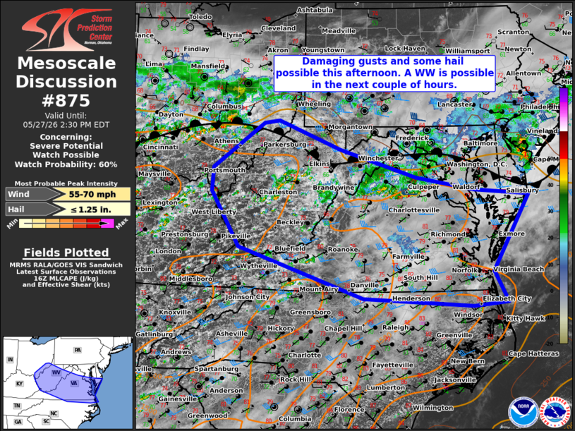
   Mesoscale Discussion 0875
   NWS Storm Prediction Center Norman OK
   1131 AM CDT Wed May 27 2026

   Areas affected...portions of the Ohio valley and Mid Atlantic

   Concerning...Severe potential...Watch possible

   Valid 271631Z - 271830Z

   Probability of Watch Issuance...60 percent

   SUMMARY...Scattered to numerous thunderstorms are expected this
   afternoon across parts of southern OH and northeastern KY into WV
   and the DelMarVA. A mixed storm mode should promote a risk for
   damaging gusts, though some hail is also possible. One or more
   severe thunderstorm watches will probably be issued in the next
   couple of hours.

   DISCUSSION...As of 1630 UTC, visible and radar imagery showed
   initial thunderstorms gradually intensifying over the OH Valley with
   clearing and deepening cumulus farther east. Weak ascent from a
   broad upper trough over the northern Great Lakes is overspreading an
   east-west frontal zone amidst midday heating. To the south of the
   front, a very moist air mass is in place with dewpoints in the low
   70s F. As surface temperatures warm near 80 F, destabilization
   should continue this afternoon. Despite modest mid-level lapse
   rates, 1000-1500 J/kg of MLCAPE and little inhibition will allow for
   scattered to widespread thunderstorms.

   A belt of enhanced westerly flow associated with the upper trough
   will continue to shift eastward near the front supporting modest
   deep-layer shear around 20-25 kt. Initial storms over OH and KY are
   likely to be multi cellular with brief organization potential and
   some clustering. As deep-layer shear increases to 30-35 kt over WV
   and the Mid Atlantic states, a few marginal supercell structures and
   some linear segments are also possible.

   As thunderstorms develop and eventually cluster, damaging gust
   potential should increase this afternoon over the OH Valley, with
   additional development and the severe threat spreading eastward with
   time. The brief stronger updrafts may also pose a risk for some
   hail, but mid-level temperatures and lapse rates are not overly
   favorable. Hail potential may be maximized with any storms that
   remain more discrete.

   Confidence in a sustained severe risk is highest farther east where
   the best overlap of deep-layer shear and buoyancy are expected
   (WV/VA into southern MD/DE). Given the expected increase in severe
   potential this afternoon, a WW is possible in the next couple of
   hours.

   ..Lyons/Gleason.. 05/27/2026

   ...Please see www.spc.noaa.gov for graphic product...

   ATTN...WFO...AKQ...LWX...RAH...RNK...PBZ...RLX...JKL...ILN...

   LAT...LON   37388207 38458274 38908272 39778148 39838111 39277960
               38747775 38487633 38387501 36917591 36317558 36257640
               36407905 37388207

   MOST PROBABLE PEAK WIND GUST...55-70 MPH
   MOST PROBABLE PEAK HAIL SIZE...UP TO 1.25 IN
|
|
|
Top/All Mesoscale Discussions/Forecast Products/Home |
|
Source link