| Mesoscale Discussion 874 | |
| < Previous MD | |

|
|
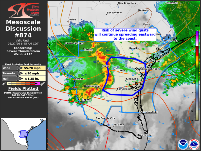
Mesoscale Discussion 0874 NWS Storm Prediction Center Norman OK 0521 AM CDT Wed May 27 2026 Areas affected...Parts of South Texas Concerning...Severe Thunderstorm Watch 245... Valid 271021Z - 271145Z The severe weather threat for Severe Thunderstorm Watch 245 continues. SUMMARY...A cluster of thunderstorms will continue to pose a risk of strong-severe wind gusts as it continues eastward to the Lower TX Coast. DISCUSSION...A forward-propagating thunderstorm cluster is tracking eastward at around 35-40 kt across South TX toward the Lower TX Coast. This activity is advancing along a zone of low-level confluence focused near an east/west-oriented outflow boundary. Given the well-established cold pool, moist pre-convective air mass, and around 40 kt of gust-front-orthogonal effective shear, this activity will continue to pose a risk of strong-severe gusts as it approaches the coast over the next hour or two. ..Weinman.. 05/27/2026 ...Please see www.spc.noaa.gov for graphic product... ATTN...WFO...CRP...BRO... LAT...LON 27249858 27459847 27729840 28029847 28189831 28149754 27999721 27689718 27289731 27099763 27109832 27249858 MOST PROBABLE PEAK TORNADO INTENSITY...UP TO 90 MPH MOST PROBABLE PEAK WIND GUST...55-70 MPH MOST PROBABLE PEAK HAIL SIZE...UP TO 1.25 IN |
|
|
Top/All Mesoscale Discussions/Forecast Products/Home |
|
Source link