| Mesoscale Discussion 873 | |
| < Previous MD | |
|
|
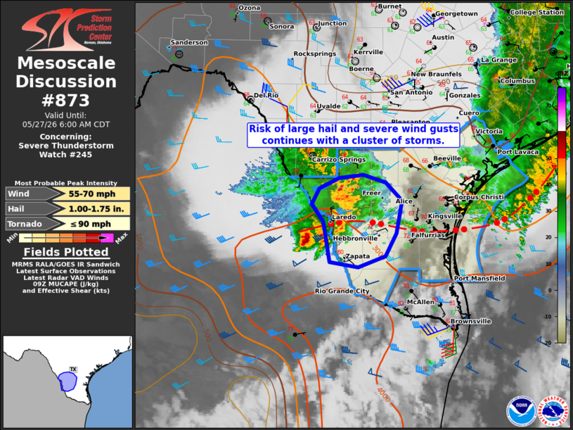
Mesoscale Discussion 0873 NWS Storm Prediction Center Norman OK 0406 AM CDT Wed May 27 2026 Areas affected...Portions of South Texas Concerning...Severe Thunderstorm Watch 245... Valid 270906Z - 271100Z The severe weather threat for Severe Thunderstorm Watch 245 continues. SUMMARY...The risk of large hail and severe wind gusts continues with a cluster of storms over South Texas -- within Severe Thunderstorm Watch 245. DISCUSSION...A cluster of thunderstorms is evolving along the east/west-oriented portion of an outflow boundary extending across South TX. Here, steep midlevel lapse rates (around 7.5 C/km per earlier 00Z observed soundings) atop rich boundary-layer moisture (middle/upper 60s to lower 70s dewpoints) are contributing to moderate instability -- even immediately north of the outflow boundary. This instability and around 40 kt of effective shear will continue to promote loosely organized convective clusters capable of producing large hail and severe wind gusts. A gust of 58 mph was recently measured in Laredo TX at 0841 UTC. Given recent radar trends and cold pool evolution with respect to the west-southwesterly deep-layer shear, there is some potential that a forward-propagating cluster of storms tracks east-southeastward along the outflow boundary. This evolution would increase the risk of severe wind gusts. ..Weinman.. 05/27/2026 ...Please see www.spc.noaa.gov for graphic product... ATTN...WFO...CRP...BRO... LAT...LON 27339836 26989856 26819902 26889952 27519963 27789982 28029969 28189935 28239894 28109855 27829826 27339836 MOST PROBABLE PEAK TORNADO INTENSITY...UP TO 90 MPH MOST PROBABLE PEAK WIND GUST...55-70 MPH MOST PROBABLE PEAK HAIL SIZE...1.00-1.75 IN |
|
|
Top/All Mesoscale Discussions/Forecast Products/Home |
|
Source link