| Mesoscale Discussion 872 | |
| < Previous MD | |
|
|
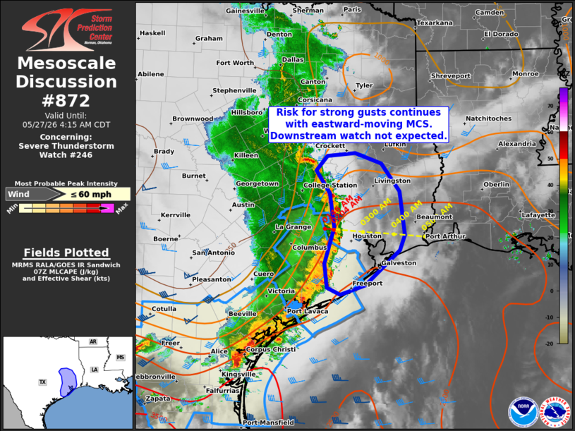
Mesoscale Discussion 0872 NWS Storm Prediction Center Norman OK 0221 AM CDT Wed May 27 2026 Areas affected...Parts of southeast Texas Concerning...Severe Thunderstorm Watch 246... Valid 270721Z - 270915Z The severe weather threat for Severe Thunderstorm Watch 246 continues. SUMMARY...Embedded strong to severe gusts remain possible with an eastward-moving MCS. A downstream watch issuance is not expected. DISCUSSION...The latest radar data from KHGX indicates an MCS tracking eastward across southeast TX at around 30-35 kt. Given the well-established cold pool, around 40 kt 0-6 km shear (per VWP data), and moist inflow (lower 70s dewpoints) for this system, strong to locally severe gusts (50-60 mph) will remain possible as it continues eastward over the next couple hours. However, given the orientation of the midlevel trough and accompanying midlevel flow, weakening upper-level support and increasingly line-parallel deep-layer shear should tend to limit convective intensity with eastward extent -- especially given the lack of a stronger low-level mass response. Therefore, a downstream watch is not expected. ..Weinman/Smith.. 05/27/2026 ...Please see www.spc.noaa.gov for graphic product... ATTN...WFO...LCH...HGX...FWD... LAT...LON 28959582 29379587 29989568 30579578 30969605 31219582 31279527 31099476 30619439 29859430 29599439 29009507 28849557 28959582 MOST PROBABLE PEAK WIND GUST...UP TO 60 MPH |
|
|
Top/All Mesoscale Discussions/Forecast Products/Home |
|
Source link