| Mesoscale Discussion 866 | |
| < Previous MD | |

|
|
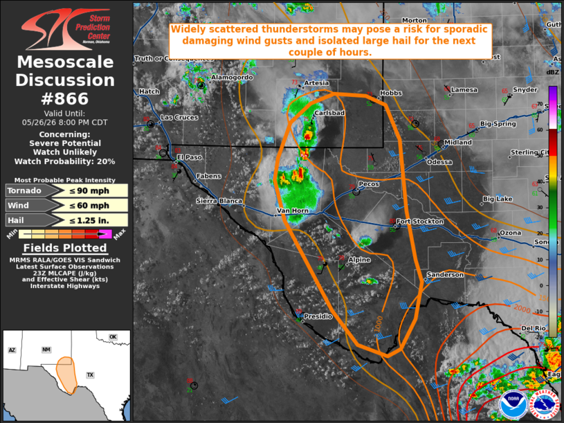
   Mesoscale Discussion 0866
   NWS Storm Prediction Center Norman OK
   0628 PM CDT Tue May 26 2026

   Areas affected...portions of southeastern New Mexico into West Texas

   Concerning...Severe potential...Watch unlikely

   Valid 262328Z - 270100Z

   Probability of Watch Issuance...20 percent

   SUMMARY...Widely scattered thunderstorms will pose a risk for
   sporadic damaging wind gusts and isolated large hail for the next
   couple of hours. Watch issuance is unlikely.

   DISCUSSION...Widely scattered thunderstorms have developed along a
   weak boundary late this afternoon in the vicinity of the Guadalupe
   and Davis Mountains in southeastern New Mexico/West Texas. This
   boundary demarcates the western periphery of a corridor of enhanced
   low-level moisture (surface dewpoints in the mid/upper 50s F), which
   is supporting weak buoyancy (generally 500-1000 J/kg across the
   region. Modest effective shear upstream of a mid/upper trough axis
   (20-25 kts per latest mesoanalysis) is sufficient to support some
   organization of updrafts into multicells and perhaps marginal
   supercell structures. Steep low- and mid-level lapse rates will
   promote a threat for sporadic damaging wind gusts and isolated large
   hail. A landspout also cannot be ruled out should a more robust,
   low-level updraft interact with enhanced surface vertical vorticity
   along this boundary. Thunderstorm activity should then gradually
   wane after another 1-2 hours owing to low-level nocturnal
   cooling/stabilization. Given the limited magnitude and the expected
   short-term nature of the severe threat, watch issuance is unlikely.

   ..Chalmers/Thompson.. 05/26/2026

   ...Please see www.spc.noaa.gov for graphic product...

   ATTN...WFO...MAF...

   LAT...LON   32140467 32350460 32620427 32760388 32730334 32600301
               32110279 31110269 30410254 30110244 29590256 29170280
               29070301 29230349 29710389 30460435 30970468 31540485
               31850479 32140467

   MOST PROBABLE PEAK TORNADO INTENSITY...UP TO 90 MPH
   MOST PROBABLE PEAK WIND GUST...UP TO 60 MPH
   MOST PROBABLE PEAK HAIL SIZE...UP TO 1.25 IN
|
|
|
Top/All Mesoscale Discussions/Forecast Products/Home |
|
Source link