| Mesoscale Discussion 862 | |
| < Previous MD Next MD > | |

|
|
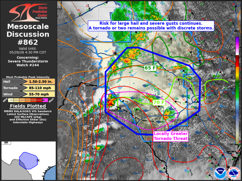
Mesoscale Discussion 0862 NWS Storm Prediction Center Norman OK 0307 PM CDT Tue May 26 2026 Areas affected...Portions of Texas Hill Country Concerning...Severe Thunderstorm Watch 244... Valid 262007Z - 262130Z The severe weather threat for Severe Thunderstorm Watch 244 continues. SUMMARY...Large hail and severe gusts will remain the greatest threat in WW 244. There is a locally more favorable zone for tornadoes between Eagle Pass and San Antonio. DISCUSSION...Linear convection from near Del Rio to east of San Angelo has yet to become more substantially organized thus far. Continued heating/moistening out ahead of this activity should eventually allow for some intensification and upscale growth to occur. West of San Antonio, discrete storms have been ongoing. Given the very moist (70+ F dewpoints) and the locally enhanced low-level shear on the KDFX VAD, these storms will pose the greatest threat of a tornado or two and potentially hail around 2 in. over the next couple of hours. With time, the expectation remains that a linear MCS will develop and move east/southeast later this afternoon. ..Wendt/Gleason.. 05/26/2026 ...Please see www.spc.noaa.gov for graphic product... ATTN...WFO...CRP...EWX...SJT... LAT...LON 29040148 30190151 30900079 30910042 30379870 30009835 29089840 28769890 28379968 28400045 29040148 MOST PROBABLE PEAK TORNADO INTENSITY...85-110 MPH MOST PROBABLE PEAK WIND GUST...55-70 MPH MOST PROBABLE PEAK HAIL SIZE...1.50-2.50 IN |
|
|
Top/All Mesoscale Discussions/Forecast Products/Home |
|
Source link