| Mesoscale Discussion 861 | |
| < Previous MD | |

|
|
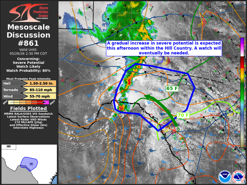
   Mesoscale Discussion 0861
   NWS Storm Prediction Center Norman OK
   1228 PM CDT Tue May 26 2026

   Areas affected...Texas Hill Country

   Concerning...Severe potential...Watch likely

   Valid 261728Z - 261930Z

   Probability of Watch Issuance...80 percent

   SUMMARY...Large hail and severe gusts will become more probable into
   the afternoon. Very-large hail and a tornado or two would be
   possible with any sustained supercells. A watch will eventually be
   needed for parts of the Hill Country.

   DISCUSSION...A line of convection continues to move eastward out of
   the Trans-Pecos/Big Bend regions. Morning sounding data from Del Rio
   showed a low-level dry pocket. Dewpoints had initially mixed down
   into the low 60s F with the onset of daytime heating, but richer
   moisture continues to advect northwestward into the Hill Country.
   The current expectation is for this convection to gradually increase
   as surface heating continues and the low levels moisten through the
   afternoon. The strongest activity will likely remain south of the
   I-10 corridor given modestly drier outflow to the north and greater
   buoyancy and effective shear closer to the Rio Grande. Steep
   mid-level lapse rates will promote large to very large hail,
   particularly with supercells. That said, shear is somewhat marginal
   for supercells and linear modes will tend to dominate. The risk for
   tornadoes is nonzero, but will depend on a supercell mode near the
   Rio Grande Valley (reference the KDFX VAD). With time, a greater
   severe wind threat should develop as convection grows upscale. A
   watch will eventually be needed, but timing of a ramp up in storm
   intensity remains the primary uncertainty.

   ..Wendt/Gleason.. 05/26/2026

   ...Please see www.spc.noaa.gov for graphic product...

   ATTN...WFO...EWX...SJT...MAF...

   LAT...LON   29450140 29500202 29580222 29830227 30220216 30760186
               30970152 30910094 30669970 30259946 29589975 28950074
               29030083 29450140

   MOST PROBABLE PEAK TORNADO INTENSITY...85-110 MPH
   MOST PROBABLE PEAK WIND GUST...55-70 MPH
   MOST PROBABLE PEAK HAIL SIZE...1.50-2.50 IN
|
|
|
Top/All Mesoscale Discussions/Forecast Products/Home |
|
Source link