| Mesoscale Discussion 859 | |
| < Previous MD | |

|
|
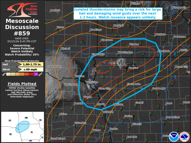
   Mesoscale Discussion 0859
   NWS Storm Prediction Center Norman OK
   0713 PM CDT Mon May 25 2026

   Areas affected...portions of the mid-Missouri Valley

   Concerning...Severe potential...Watch unlikely

   Valid 260013Z - 260145Z

   Probability of Watch Issuance...20 percent

   SUMMARY...Isolated developing thunderstorms may bring a risk for
   large hail and damaging wind gusts over the next 1-2 hours. Watch
   issuance is unlikely at this time.

   DISCUSSION...Latest visible satellite imagery and GOES lightning
   data depict isolated, developing thunderstorms along a weak surface
   trough from far northeastern Nebraska into northwestern Iowa.
   Temperatures in the upper-80s F and dewpoints in the low-60s are
   supporting  moderate buoyancy, with 1500 to locally 2500 J/kg MLCAPE
   depicted via latest objective analysis. While northwesterly
   mid-level flow remains rather weak, 20-30 kts of effective shear is
   sufficient to support some organization of more robust updrafts,
   with the potential for marginal supercell structures. The primary
   threats with these storms will be an isolated risk for large hail
   and damaging wind gusts given steep low- and mid-level lapse rates.

   The overall severe threat is expected to remain spatially and
   temporally limited, with the mostly likely scenario being one or two
   strong to severe thunderstorms evolving over the next 1-2 hours
   before nocturnal cooling/stabilization begins to bring a decreasing
   severe risk. Given this, watch issuance is unlikely, but trends will
   continue to be monitored.

   ..Chalmers/Thompson.. 05/26/2026

   ...Please see www.spc.noaa.gov for graphic product...

   ATTN...WFO...MPX...DMX...FSD...OAX...

   LAT...LON   42459719 42869719 43509668 44069539 44089445 43949397
               43619375 43089385 42679419 42389485 42099560 41889626
               41989684 42189711 42459719

   MOST PROBABLE PEAK WIND GUST...UP TO 60 MPH
   MOST PROBABLE PEAK HAIL SIZE...1.00-1.75 IN
|
|
|
Top/All Mesoscale Discussions/Forecast Products/Home |
|
Source link