| Mesoscale Discussion 858 | |
| < Previous MD | |

|
|
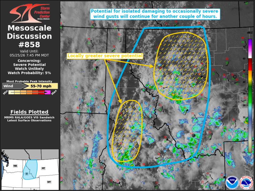
   Mesoscale Discussion 0858
   NWS Storm Prediction Center Norman OK
   0646 PM CDT Mon May 25 2026

   Areas affected...portions of the Northern Rockies

   Concerning...Severe potential...Watch unlikely

   Valid 252346Z - 260145Z

   Probability of Watch Issuance...5 percent

   SUMMARY...Potential for isolated damaging to occasionally severe
   wind gusts will continue for a few more hours. Watch issuance is not
   expected.

   DISCUSSION...Isolated high-based convection is ongoing across
   portions of the Northern Rockies from central Idaho into western
   Montana, with several reports of damaging to severe wind gusts noted
   with this activity over the least 1-2 hours. Latest objective
   analysis depicts weak buoyancy (250-750 J/kg MLCAPE) across this
   region, with a modified 18z BOI observed sounding depicting a deep,
   well-mixed boundary layer with an inverted-v thermodynamic profile.
   As this convection continues to evolve north-northeastward over the
   next couple of hours, it will encounter accelerating mid-level flow
   (sampled by the PDT/OTX VAD profiles) ahead of a robust mid/upper
   trough digging into the Pacific Northwest. Steep low-level lapse
   rates and dry boundary layer profiles will continue to promote
   efficient evaporative cooling and downward momentum transport, with
   the resultant potential for isolated damaging to occasionally severe
   wind gusts.

   Latest high-res guidance suggests that some clustering of ongoing
   convection along developing cold pools may occur over the next 1-2
   hours as storms evolve north-northeastward. In this scenario, a
   corridor or two of locally greater severe wind potential may
   develop. The greatest potential will likely be across portions of
   west-central into northwestern Montana where guidance suggests a
   pool of locally greater buoyancy may exist. Watch issuance is not
   expected at this time, however, given the isolated nature of the
   severe threat.

   ..Chalmers/Thompson.. 05/25/2026

   ...Please see www.spc.noaa.gov for graphic product...

   ATTN...WFO...TFX...PIH...MSO...BOI...OTX...PDT...

   LAT...LON   44791682 45951684 46601667 47491617 48281562 48931515
               49041496 49061366 49071265 49061197 48811185 48041166
               47421166 46541177 45331213 44631243 44371302 44261377
               44131483 44161600 44351653 44791682

   MOST PROBABLE PEAK WIND GUST...55-70 MPH
|
|
|
Top/All Mesoscale Discussions/Forecast Products/Home |
|
Source link