| Mesoscale Discussion 857 | |
| < Previous MD | |

|
|
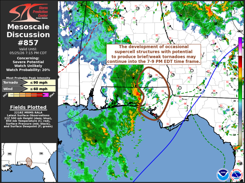
   Mesoscale Discussion 0857
   NWS Storm Prediction Center Norman OK
   0520 PM CDT Mon May 25 2026

   Areas affected...parts of the Florida Panhandle...southeastern
   Alabama...adjacent southwestern Georgia

   Concerning...Severe potential...Watch unlikely

   Valid 252220Z - 260015Z

   Probability of Watch Issuance...20 percent

   SUMMARY...The development of occasional supercell structures posing
   a risk for brief, weak tornadoes may continue into early evening.
   Due to the marginal/limited nature of this potential, it is not
   clear that a severe weather watch is needed, but trends are being
   monitored.

   DISCUSSION...A modest belt of mean southerly ambient flow (on the
   order of 20-30 kt) has developed inland across Alabama and Florida
   Panhandle coastal areas, in association with a northeastward
   migrating remnant mesoscale convective vortex to the northwest.
   This has contributed to wind profiles including modest low-level
   hodographs with clockwise curvature, along a low-level confluence
   band which is providing a focus for vigorous thunderstorm
   development extending west of Crestview FL southward offshore.

   This convection is being supported by inflow of near saturated,
   seasonably moist (including surface dew points in the lower/mid 70s
   F) boundary layer air supportive of sizable CAPE up to around 2000
   J/kg.  And the environment has become conducive to supercell
   structures with potential to produce brief/weak tornadoes.  Given
   the marginal nature of the wind profiles, the the enhancement of the
   near-surface buoyancy, and potential upward parcel accelerations,
   associated with the higher moisture content has probably been
   necessary to support this activity.  It is possible that this could
   continue another few hours and perhaps spread a bit farther inland.

   ..Kerr/Thompson.. 05/25/2026

   ...Please see www.spc.noaa.gov for graphic product...

   ATTN...WFO...TAE...BMX...MOB...

   LAT...LON   31128626 31628590 31518547 31118513 30598506 29948552
               30238617 30708599 31128626

   MOST PROBABLE PEAK TORNADO INTENSITY...UP TO 90 MPH
   MOST PROBABLE PEAK WIND GUST...UP TO 60 MPH
|
|
|
Top/All Mesoscale Discussions/Forecast Products/Home |
|
Source link