|
|
| Mesoscale Discussion 856 | |
| < Previous MD | |

|
|
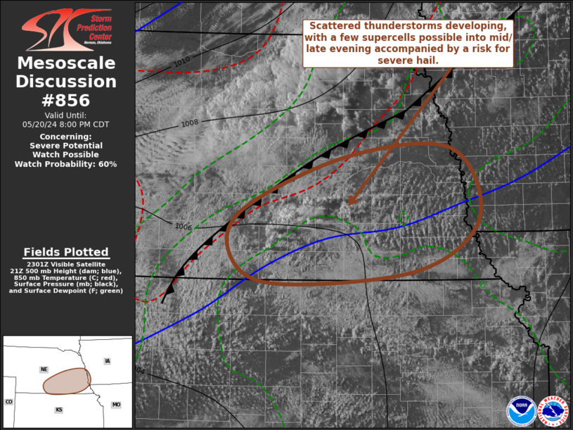
   Mesoscale Discussion 0856
   NWS Storm Prediction Center Norman OK
   0606 PM CDT Mon May 20 2024

   Areas affected...parts of south central and southeastern Nebraska

   Concerning...Severe potential...Watch possible

   Valid 202306Z - 210100Z

   Probability of Watch Issuance...60 percent

   SUMMARY...Scattered strong thunderstorm development is initiating
   across the region and probably will persist into mid/late evening.
   A few supercells are possible, primarily posing a risk for large
   hail.

   DISCUSSION...Deepening convective development is underway where
   boundary-layer destabilization has become maximized in a corridor
   from near the Hastings/Kearney vicinity into the Greater Omaha area.
   This is in advance of a slowly southeastward advancing cold front,
   where lower/mid-tropospheric warming across much of the central
   Great Plains may be offsetting weakening of inhibition associated
   with insolation.  Still, roughly to the north of the Kansas/Nebraska
   border, temperatures in the 700-500 mb layer remain cooler relative
   to areas to south, and it appears inhibition is weak enough to allow
   for intensifying thunderstorm development during the next few hours.

   Mid/upper support for upward vertical motion remains uncertain, but
   strong southwesterly flow in mid/upper levels is contributing to
   sufficient deep-layer shear for supercell development.  With
   mixed-layer CAPE in excess of 2000 J/kg beneath steep mid-level
   lapse rates, stronger storms may pose an initial risk for severe
   hail.

   Although boundary-layer cooling will contribute to increasing
   inhibition into and after sunset, modest strengthening of southerly
   850 mb flow and associated warm advection may maintain stronger
   cells into mid/late evening.

   ..Kerr.. 05/20/2024

   ...Please see www.spc.noaa.gov for graphic product...

   ATTN...WFO...OAX...GID...

   LAT...LON   40829950 41519778 41609607 40759563 40129661 39959878
               40219958 40829950
|
|
|
Top/All Mesoscale Discussions/Forecast Products/Home |
|