| Mesoscale Discussion 854 | |
| < Previous MD | |
|
|
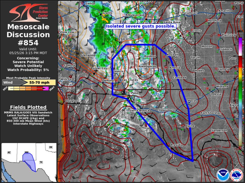
   Mesoscale Discussion 0854
   NWS Storm Prediction Center Norman OK
   0220 PM CDT Mon May 25 2026

   Areas affected...portions of West Texas and southern New Mexico

   Concerning...Severe potential...Watch unlikely

   Valid 251920Z - 252115Z

   Probability of Watch Issuance...5 percent

   SUMMARY...Scattered thunderstorms may pose a risk for isolated
   severe wind gusts into this evening.

   DISCUSSION...Scattered thunderstorms have developed across portions
   of southern NM and West TX this afternoon in response to weak ascent
   and strong diurnal heating east of a weak upper low over the
   Southwest. Continued heating will likely allow for additional
   development given a broad, but weakly unstable air mass (SBCAPE
   500-1000 J/kg) over the southern Rockies/High Plains. Enhanced
   southerly flow aloft will support some potential for organized multi
   cells and clusters, given 20-30 kt of effective shear.

   Increasing storm coverage is expected with further heating and weak
   ascent overspreading the Davis mountains and Mexican Plateau this
   afternoon. This could support a few strong to severe wind gusts as
   low-level lapse rates are steep, with LCLs of 2500-3000 m. While
   some severe risk is possible into this evening, the limited buoyancy
   and moisture should keep the threat isolated. Severe potential will
   be relatively maximized with any longer-lived multi cell clusters
   that can become established. Still, the limited organization
   potential suggests a watch is unlikely.

   ..Lyons/Gleason.. 05/25/2026

   ...Please see www.spc.noaa.gov for graphic product...

   ATTN...WFO...MAF...ABQ...EPZ...

   LAT...LON   33900658 33900510 33370433 31160345 28940329 29370432
               31600650 31760719 33260725 33900658

   MOST PROBABLE PEAK WIND GUST...55-70 MPH
|
|
|
Top/All Mesoscale Discussions/Forecast Products/Home |
|
Source link